
Volcanic arc/belt Kermadec Islands Elevation 516 m | Last eruption March 2006 Island group Kermadec Islands | |
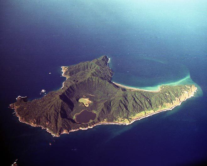 | ||
Raoul island on tv3 new zealand
Anvil-shaped Raoul Island (Sunday Island), the largest and northernmost of the main Kermadec Islands, 900 km (560 mi) south south-west of 'Ata Island of Tonga and 1,100 km (680 mi) north north-east of New Zealand's North Island, has been the source of vigorous volcanic activity during the past several thousand years that was dominated by dacitic explosive eruptions.
Contents
- Raoul island on tv3 new zealand
- Map of Raoul Island New Zealand
- A raoul island christmas story
- History
- Geography
- Climate
- Flora and fauna
- Satellite islands and rocks
- 2006 eruption
- July 2011 76 earthquake
- October 2011 74 earthquake
- Mihai Muncus Nagy
- References
Map of Raoul Island, New Zealand
The area of the island, including fringing islets and rocks mainly in the northeast, but also a few smaller ones in the southeast, is 29.38 km2 (11 sq mi). The highest elevation is Moumoukai Peak, at an elevation of 516 m (1,693 ft).
Although Raoul is the only island in the Kermadec group large enough to support settlement, it lacks a safe harbour, and landings from small boats can only be made in calm weather. The island consists of two mountainous areas, one with summits of 516 metres (1,693 ft) and 498 metres (1,634 ft), and the other with a summit of 465 metres (1,526 ft), the two separated by a depression which is the caldera of the Raoul volcano.
Considering offshore islets and rocks, the northernmost island of New Zealand is Nugent Island, about 100 metres (328 ft) in diameter, located 3.6 km (2.2 mi) northeast of Raoul Island. The coordinates of the northernmost point are 29°13′52″S 177°52′09″W. Napier Island stretches almost as far north as Nugent Island, which reaches just a few metres further north.
A raoul island christmas story
History
Stone implements of the Polynesian type have been found on Raoul Island, and there is indication of a prehistoric settlement (see below). But the island was uninhabited when first sighted by Western sailors.
The island was named after Joseph Raoul, quartermaster of the Recherche, when it was sighted on 16 March 1793. Captain W. Raven of the whaler Britannia sighted the island on 6 March 1796 and called it Sunday Island, a name which was subsequently in common usage. Captain Henry Mangles Denham of HMS Herald charted the island in 1854.
The last regular occupants, Tom Bell and his wife Frederica, spent thirty-six years on the island before the New Zealand government evacuated them in 1914.
From 27 May to 16 June 1917, the German raider Wolf, under the command of Korvettenkapitän Karl August Nerger, anchored in the protected bay to undertake engine overhaul and maintenance. During this period Wolf captured the New Zealand steamship Wairuna (3,950 tons) and the American sailing bark Winslow (570 tons), commandeering all cargo and coal from both ships. A landing party sent to investigate the island found out how hasty the evacuation of the Bells was – a 1914 calendar was still pinned to the kitchen wall and the family's furniture, cutlery, and child's toys had remained in place.
The New Zealand government has permanently manned Raoul Island Station since 1937. It includes a government meteorological and radio station and hostel for Department of Conservation (DOC) officers and volunteers. The station stands on the northern terraces of the island, about 50 m (164 ft) in elevation above the cliffs of Fleetwood Bluff.
When the New Zealand government established a weather and radio station on the island in 1939 it made Raoul the official name, probably to avoid confusion with a number of Sunday islands in Australia. Raoul Island Station represents the northernmost outpost of New Zealand.
Geography
Two Holocene calderas are found at Raoul. The older caldera cuts the center of Raoul Island is about 2.5 km × 3.5 km (1.6 mi × 2.2 mi) long and wide respectively. Denham caldera, formed during a major dacitic explosive eruption about 2200 years ago, truncated the western side of the island and is 6.5 km × 4 km (4.0 mi × 2.5 mi) long and wide respectively. Its long axis is parallel to the tectonic fabric of the Havre Trough that lies west of the volcanic arc.
Historical eruptions at Raoul during the 19th and 20th centuries have sometimes occurred simultaneously from both calderas, and have consisted of small-to-moderate phreatic eruptions, some of which formed ephemeral islands in Denham caldera. A 240 m (787 ft) high unnamed submarine cone, one of several located along a fissure on the lower NNE flank of Raoul volcano, has also erupted during historical time, and satellitic vents at Raoul are concentrated along two parallel NNE-trending lineaments.
The Denham caldera was named for the nearby Denham Bay, itself named by Capt Henry Mangles Denham in Herald who came to complete a (chart) survey of the island on 2 July 1854. His son Fleetwood James Denham (16yrs) died from a tropical fever, and was buried near the beach at the head of Denham Bay, where a number of the grass-grown graves of former settlers were. The brass plaque heading this grave has been preserved.
Three small lakes, Blue Lake (1.17 km2 or 0.45 sq mi, about 40% overgrown), Green Lake (160,000 m2 or 1,700,000 sq ft) and Tui Lake (5,000 m2 or 54,000 sq ft, drinking water quality) are located in the northern caldera of Raoul Island. The plains surrounding the lakes are called Pumice Flats.
Climate
Raoul Island has a humid subtropical climate.
Flora and fauna
The scientific categorisation of the flora and fauna of the island began in 1854 when HMS Herald, captained by Henry Mangles Denham, arrived to complete the charting of the island. He arrived on the 2nd and was occupied till 24 July, during which time he frequently had to move the ship on account of the rough weather experienced. William Grant Milne and John MacGillivray, naturalists on board the Herald, made a small collection of plants on Raoul. This was forwarded by Captain Denham to Sir W. Hooker, and was described by Sir Joseph Hooker in the Journal of the Linnean Society for 1857.
A scientific expedition was undertaken by a group of naturalists to the Kermadec Islands in 1908. The expedition established its base at Denham Bay. During that expedition one of the naturalists, W. L. Wallace, discovered numerous new insect species including the beetle Saprosites raoulensis.
Raoul is part of the Kermadec Islands subtropical moist forests ecoregion and is largely covered with closed-canopy forest, predominantly of the evergreen Kermadec pōhutukawa (Metrosideros kermadecensis) and the Kermadec nikau palm (Rhopalostylis baueri, formerly described as Rhopalostylis cheesemanii). It is just far enough south that the occasional fertile coconut from Polynesia that washes up on shore and takes root will not survive in the longterm due to a lack of warmth. The island has no native land mammals and was formerly home to vast colonies of seabirds who nested in the forests. The islands may once have had a species of megapode (based on early settler records) and a subspecies of kereru. Currently native landbirds on the island include the Kermadec red-crowned parakeet (Cyanoramphus novaezelandiae cyanurus), the Australasian harrier, pukeko, tui and several introduced species. The island forms part of the Kermadec Islands Important Bird Area, identified as such by BirdLife International because it is an important site for nesting seabirds.
Polynesian visitors introduced the Polynesian rat in the 14th century and Norway rats, cats and goats were introduced by European and American visitors in the 19th and 20th centuries. The rats and cats greatly reduced the seabird colonies, which mostly withdrew to offshore islets, and exterminated the red-crowned parakeet, the last confirmed record of resident parakeets for over a century being made in 1836. Although the goats did not eliminate the tree canopy as they did on other islands, they greatly reduced the understory vegetation and were removed in 1986. The Department of Conservation eradicated rats and cats between 2002 and 2006, following which red-crowned parakeets soon returned naturally, presumably from the Herald Islets, 2–4 km (1.2–2.5 mi) away. The parakeets had been absent from the island for 150 years and their natural return was a notable event in parrot conservation.
There are numerous invasive plant species on the island and a large scale weeding programme involving teams of DOC workers and volunteers has been under way for a number of years in an attempt to eradicate them.
The island is part of the Kermadec Islands Marine Reserve, New Zealand's largest marine reserve, which was created in 1990.
Satellite islands and rocks
The two largest satellite islands are North Island and South Island of Meyer Islands.
2006 eruption
On 17 March 2006 at 8:21 a.m. NZDT, a 40-second long volcanic eruption occurred at the Green Lake. At the time, Mark Kearney, a 33-year-old DOC worker, was at the crater taking water temperature measurements. A 5-hectare (12-acre) area around Green Lake was affected with ash, mud and boulders. Two DOC workers were forced to turn back after going to the crater to search for Kearney.
Following the eruption, DOC decided to evacuate the remaining five staff members. A Mil Mi-8 helicopter and Piper PA-31 Navajo aircraft took off from Taupo at 11 a.m. that morning. They arrived at the island in the late afternoon and undertook a 45-minute search for Kearney but no sign was seen. The evacuated staff members were brought back to Auckland that evening.
A Royal New Zealand Air Force P-3 Orion made an overflight on 21 March to provide further information on how safe it is to approach Green Lake. The volcanologists aboard decided the area was still unsafe, and that the crater lake had risen by about 8 metres (26.2 ft) compared to measurements taken on 17 March. There was no cloud or ash plume.
A group of police, the five evacuated workers, three other DOC staff and scientific staff left Tauranga on 18 March for the three-day boat trip to Raoul aboard the RV Braveheart to recover Kearney's body. They were able to undertake a limited search, but decided that it was extremely unlikely that Kearney survived given the amount of devastation in the area around Green Lake. The Braveheart began the journey back to the mainland on 25 March, with three of the DOC workers staying on the island to continue research. The three were joined by the other four evacuated workers at the start of May 2006. Two of the three will return to the mainland after the handover.
Five hours after the eruption, the Aura satellite passed over and found an estimated 200 tonnes (197 long tons; 220 short tons) of sulfur dioxide had been released. This confirmed that there were magmatic gases in the eruption, and the presence of degassing magma within the volcano. By the end of April, the activity in the area had decreased significantly and the "Alert Level" was lowered to 1.
HMNZS Te Mana left for Raoul on 24 August 2006 on a resupply mission. Also on board were Kearney's sister, Merryn McDermott; three representatives of the Ngāti Kurī iwi; and Chris Carter, the Minister of Conservation. During a service held on 28 August, the Ngāti Kurī representatives performed a tapu lifting ceremony. A plaque was erected to honour Kearney. Te Mana also allowed some volcanic monitoring to be undertaken using its SH-2G Super Seasprite helicopter. During a dawn flight, sample bottles were filled with crater lake water.
A report by the New Zealand Department of Labour into the death was released on 14 October 2006. It cleared the Conservation Department and Geological and Nuclear Sciences of any negligence related to the death of Kearney. The report stated that the eruption was unpredictable and there was no indication of imminent seismic activity.
As a geographically active 'hotspot', the Kermadec Islands also experience frequent earthquakes, the most recently significant of which occurred at 22:39 NZST on 16 May 2006. The epicentre was approximately 290 km (180 mi) SSW from Raoul and measured 7.4 on the moment magnitude scale, and as such is classified as a 'major' earthquake by the United States Geological Survey. It was felt as far away as Christchurch, New Zealand some 1,500 km (930 mi) from the epicentre. Also of note on 31 January 2007 at 4:15:55 NZST a Magnitude 6.5 (Strong) earthquake shook the island. The epicenter was approximately 40 km (25 mi) S of Raoul and 10 km (6.2 mi) below the seabed. On 9 December 2007 at 8.28pm NZST a magnitude 7.6 earthquake shook the area, centered approximately 350 km (220 mi) north of Raoul Island at a depth of 188 km (117 mi). On 30 September 2008 at 3:19:31 NZST a magnitude 7.0 earthquake centered 70 km (43 mi) S of Raoul occurred, with an approximate depth of 35 km (22 mi). More recently on October 22, 2011 at 05:57:17 NZST a Magnitude 7.4 earthquake originating at 28.941S 176.045W at a depth of 39 km occurred according to the United States Geological Survey.
July 2011 7.6 earthquake
7 July 2011 – 7:03AM. A 7.6 Magnitude earthquake occurred at a depth of 24 km, 211 km east of Raoul Island. 7 July 2011 – 8.51 AM Pacific Tsunami Warning Center scientist Barry Hirshorn told Newstalk ZB the quake generated a 1.9 metre tsunami at Raoul Island.
October 2011 7.4 earthquake
22 October 2011 – 5.57PM. A 7.4 magnitude earthquake occurred at a depth of 45 metres (148 feet), 230 km (143 mi)east of Raoul Island.
The Ministry of Civil Defence had issued the advisory while it assessed the severity of the threat to New Zealand. The Ministry was warning people in coastal areas to stay off beaches and out of the water. People were advised to avoid sightseeing and remain on alert in case the earthquake has generated a tsunami, however by mid-morning warnings had lifted.
Mihai Muncus-Nagy
Department of Conservation volunteer Mihai Muncus-Nagy, a 33 year old biologist from Romania, went missing on Raoul Island on 2 January 2012. He went to Raoul at the end of October 2011. His vehicle and gear was found close to where he was carrying out water temperature readings on the morning of 2 January 2012.
The remaining staff and volunteers searched the shore, but had not found any further signs of him. A helicopter was sent to Raoul by the Rescue Coordination Centre New Zealand (RCCNZ) from Taupo, New Zealand to carry out an aerial search. A DOC boat was also used in the search.
Muncus-Nagy has been presumed drowned.