
Country Bangladesh Area 3.84 km² | Time zone BST (UTC+6) | |
 | ||
Website Official Map of the Ramna Thana | ||
Ramna (Bengali: রমনা) is a historic colonial neighborhood in central Dhaka. Once the site of Mughal gardens, it developed into an institutional area during British rule in the late 19th century. It became a focal point for Dhaka's modernization in the 1960s. It was the scene of many tumultuous events that ushered the independence of Bangladesh in 1971.
Contents
Map of Ramna, Dhaka, Bangladesh
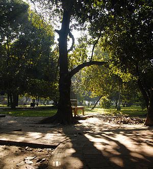
The Ramna Park (also known as Ramna Green) is the largest park in Dhaka, seen being akin to Calcutta's Maidan, London's Hyde Park and New York's Central Park. The Suhrawardy Udyan (formerly the Ramna Race Course Maidan) is the second largest park in Dhaka. The annual parades and concerts of the Bengali New Year take place in Ramna.
Ramna hosts the University of Dhaka, the Bangladesh Supreme Court, the Dhaka High Court, the Ministry of Foreign Affairs, CIRDAP, the Institution of Engineers, Bangladesh headquarter, the InterContinental Dhaka hotel, the Dhaka Club, the Bangladesh National Museum, the Bangla Academy, the International Mother Language Institute, the Dhaka Medical College, BIRDEM Hospital, the British Council Dhaka, the Faculty of Fine Arts, the Shaheed Minar, the official residences of the Bangladeshi ministers and official state guest houses.
Geography
Ramna is at 23.7417°N 90.4083°E / 23.7417; 90.4083. It has an area of 3.84 square kilometres (1.48 sq mi).
Demographics
As of the 1991 Bangladesh census, Ramna had a population of 195,167. Males constituted 58.32% of the population and females 41.68%. The thana's population of those age 18 and higher was 127,049.