
Maintained by British Waterways Length 85 feet (25.9 m) Fall 3 feet 3 inches (1 m) Waterway Lee Navigation | Operation Manual Width 16 feet (4.9 m) First built 1864 | |
 | ||
County London Borough of EnfieldGreater London | ||
Speeded up canal journeys river lee waltham common lock to rammey marsh lock
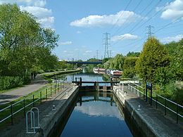
Rammey Marsh Lock (No 12) is a lock on the River Lee Navigation at Enfield, London, England. The area adjacent to the lock is known as Rammey Marsh and close to the River Lee Flood Relief Channel.
Contents
Etymology
Rammey Marsh is marked thus on the Ordnance Survey map of 1887, named from Ramhey 1538, Rammey 1610, probably 'island (of dry ground in marsh) where rams are pastured', from Old English ramm and ēg.
History
The lock and the adjoining cut are of 1864. Across the lock tail, a reused cast- iron footbridge dated 1835.
Public access
Vehicular access only from the north via Lea Valley Walk. Which can be accessed at Lea Road.
Pedestrian and cycle access via the towpath which forms part of the Lea Valley Walk.
Angling is allowed on the River Lee Navigation towpath downstream of Ramney Marsh Lock. Information from the River Lea Anglers Club.
Public transport
Nearest station Enfield Lock or Waltham Cross