
Opening date 2006 Length 11200 m Height 44 m | Creates Rajghat Reservoir Opened 2006 Construction began 1975 | |
 | ||
Similar Matatila Dam, Bansagar Dam, Gandhi Sagar Dam, Parichha Dam, Madikheda Dam | ||
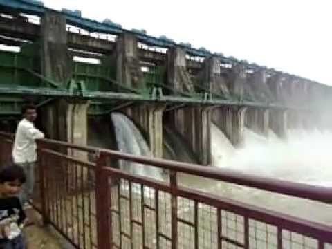
Rajghat dam 16 gate open on 7 8 11
Rajghat Dam is an Inter-state Dam project of the Government of Madhya Pradesh and Uttar Pradesh being constructed on Betwa River about 14 km from Historical place Chanderi in Madhya Pradesh and 22 km from Lalitpur in Uttar Pradesh, India. The project envisages construction of 43.80 m high and 562.50 m long masonry dam across River Betwa flanked by an earthen dam having maximum height of 29.5 m and a total length of 10.79 km.
Contents
- Rajghat dam 16 gate open on 7 8 11
- Map of Rajghat Dam Bakalwara Uttar Pradesh 473446
- Rajghat dam bridge submerged
- References
Map of Rajghat Dam, Bakalwara, Uttar Pradesh 473446
The project will provide irrigation to 1,380 square kilometres of land in Uttar Pradesh and 1,210 square kilometres in Madhya Pradesh. The installed capacity of the power house is 45 MW (3 x 15 MW). The costs and benefits of the project are to be shared by these two States equally.
The projects existing on the downstream are Matatila Dam Project, Dhukwan Dam and Parichha Dam. Thus, the Rajghat Dam Project will serve as mother storage for Irrigation in Uttar Pradesh and Madhya Pradesh through a cascade of hydraulic structures in the downstream of River Betwa.
Template:Anshul Gupta