
Time zone IST (UTC+5:30) Elevation 1,592 m | Settled Ancient PIN 190008 | |
 | ||
Distance from Delhi 826.4 kilometres (513.5 mi) Distance from Mumbai 2,190.8 kilometres (1,361.3 mi) | ||
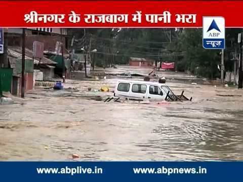
Rajbagh (Urdu;راجباغ)is the notified area in the municipal committee of Srinagar, in the Indian administered state of Jammu and Kashmir. It comes under the Amira Kadal Constituency. Rajbagh is a posh locality in the civil line area of Srinagar. The pincode of Rajbagh is 190008. Rajbagh is considered one of the many best residential places in Srinagar. There are many hotels, restaurants & schools in this locality. Rajbagh area was heavily damaged by the 2014 Kashmir floods, it was one of the worst affected areas due to flood. Nasir Aslam Wani (Sogami) of National Conference was the MLA of this neighbourhood until 2014 after he won the 2008 state elections. Businessman-turned politician Syed Altaf Bukhari of PDP is currently the MLA of this area which comes under the Amira Kadal constituency. He won this constituency during the 2014 state elections by a large margin thus putting an end to Wani's rule after 6 years.
Contents
- Map of Rajbagh Srinagar 190008
- Geography
- Subdivisions
- Education
- September floods
- Hospitals
- Restaurants
- Hotels
- References
Map of Rajbagh, Srinagar 190008
Geography
Rajbagh is iituated along the river banks of Jehlum River. It is located about 3.2 km from the commercial center of Kashmir. Ram Munshi Bagh, Shivpora, Guzarwaan Mohalla, Jawahar Nagar are the nearby localities to Rajbagh. The area is located at an R.L. of 1592 metres above mean sea level in Mumbai.
Subdivisions
Education
There are more than 15 schools in the area. The prestigious girls school Presentation Convent High School is located in this area.
The area consists of following schools
September floods
The area was damaged quite heavily by the 2014 Kashmir floods. At about 4:18 AM on 7 September water started to enter the ground floors of the houses located in this locality & by 3 PM the water level had reached about 25 feet high above ground level on the streets. Some houses were fully submerged in water, others were partially submerged, people were rescued from their houses by locals in shikaras & rafting boats. The water finally vanished in Rajbagh after 25 days. Rajbagh was submerged under water for 25 days after the flood came. The damage level was quite high in the Rajbagh area. It was one of the worst affected areas during the flood.