
Location Pacific Ocean Highest elevation 437 m (1,434 ft) Elevation 437 m | Archipelago Australes Highest point Mount Hiro Administrative subdivision Australes Area 16 km² | |
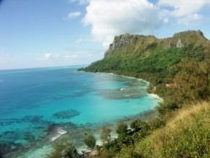 | ||
Raivavae is an island that is part of the Austral Islands in French Polynesia.
Contents
Map of Raivavae, French Polynesia
It covers an area of 16 km² and at the 2012 census had a population of 940. Its highest point is the top of an extinct volcano which is 437 meters high.
History
First sighting by Europeans was recorded by the Spanish naval officer Tomás Gayangos on board of the frigate "El Aguila" on 5 February 1775. Gayangos had taken over the command of the expedition of Domingo de Bonechea of 1774 after his death in Tahiti and was returning to the Viceroyalty of Peru. Main source describing this sighting is that of José Andía y Varela, pilot of the packet boat Jupiter that accompanied El Aguila in this return trip. On 6 February a boat was sent in, and made contact with the inhabitants at the shore edge, but landing was not made. Raivavae was charted as Santa Rosa by the Spaniards. The inhabitants said the name of their island was Oraibaba.
It was annexed by France in 1880.
Administration
The island of Raivavae is administratively within the commune with the same name. Raivavae consists of the following associated communes: