
Length 5.6 mi (9 km) Elevation change 4,000 ft (1,200 m) | Use Hiking | |
 | ||
Trailheads Mount Le Conte, Tennessee (trailhead near LeConte Creek off Cherokee Orchard Road, near Gatlinburg, TennesseeTerminus near the LeConte Lodge Highest point Terminus near the LeConte Lodge Similar Great Smoky Mountains, Great Smoky Mountain, Alum Cave Trail, Mount Le Conte, Laurel Falls Trail | ||
The Rainbow Falls Trail is an American hiking trail in the Great Smoky Mountains National Park, in Sevier County, Tennessee. The trail ascends Mount Le Conte, the tallest (and sixth-highest) mountain east of the Mississippi River, and passes Rainbow Falls before absorbing the Alum Cave Trail and terminating near the LeConte Lodge.
Contents
- Map of Rainbow Falls Trail Gatlinburg TN 37738 USA
- Information
- Landmarks and overlooks
- Trailhead to Rainbow Falls
- Rainbow Falls to LeConte Lodge
- Maps and directions
- Topographic maps
- References
Map of Rainbow Falls Trail, Gatlinburg, TN 37738, USA
Information
Landmarks and overlooks
Trailhead to Rainbow Falls
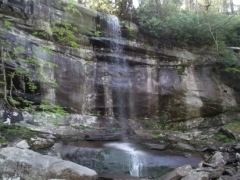
The trail asserts itself from the beginning, immediately ascending Le Conte's flank, alongside the mountain's primary drainage avenue, LeConte Creek, which, due to the abnormally large number of mills that sprouted up along this stream at one time (twelve, at its peak), was once known as "Mill Creek". The roaring sounds of the creek accompany the footpath for most of the first 2.6 miles (4.2 km), only dying down at about the 1.5-mile (2.4 km) mark, where the trail temporarily jaunts away from the stream. The path soon swings back, crossing over LeConte Creek twice via narrow footbridges over the final mile to Rainbow Falls. When hikers reach Rainbow Falls, they have hiked 2.6 miles (4.2 km) and are in the presence of the highest single-drop waterfall in the national park. On the somewhat rare occasion of a sunny afternoon at the falls, a lucky onlooker can see a rainbow reflected in the sprayed mist of the waterfall, hence the Rainbow Falls moniker.
Rainbow Falls to LeConte Lodge
From Rainbow Falls, the trail continues as a third footbridge over LeConte Creek, which the hiker bids farewell to from this point on. Over the next three miles (5 km), the trail continues its steady climb towards the lodge, cutting switchbacks through sandstone chutes, offering both the trail's first scenic overlooks and a peaceful interlude with nature, as most of the hiker's companions have been left behind at the falls. Rhododendron, sand myrtle, and mountain laurel blanket the trail during this portion, offering springtime visitors a beautiful carpeting of purples, whites, and blends of pink. At 5.4 miles (8.7 km), the trail comes to Rocky Spur, an outcropping of rocks that offers splendid views of the valleys below via a short side trail which loops back to the main trail. As the hiker continues on, s/he enters into a fragrant spruce fir forest, which signals the looming junction with the Bullhead Trail, at 6.0 miles (9.7 km). From that point, the now very rocky trail ascends for a half mile towards LeConte Lodge. The LeConte Lodge provides the only commercial lodging in the national park, as it operates about ten rustic cabins with no electricity or appliances. The lodge also operates an office which provides T-shirts and other merchandise for hikers and various amenities for guests of the lodge. For many, this signals the end of their journey, but the actual peaks of Le Conte all have separate trails a short distance from the lodge, with Cliff Tops and Myrtle Point each offering expansive panoramas of the mountains and valleys below.
Maps and directions
Topographic maps
The Abrams Falls Trail is shown on the following 1:24,000-scale topographic maps published by the National Park Service: