
Country New Zealand Local time Friday 1:54 AM | Region Marlborough | |
 | ||
Weather 11°C, Wind S at 3 km/h, 93% Humidity | ||
Pelorus river views rai valley new zealand hd review
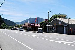
Rai Valley is a locality in Marlborough, New Zealand. State Highway 6 runs through the area. The Rai River runs past the locality to join the Pelorus River at the locality of Pelorus Bridge to the south. Nelson is 48 km to the west. Okiwi Bay is 22 km to the northeast. Canvastown is 17 km to the southeast.
Contents
- Pelorus river views rai valley new zealand hd review
- Map of Rai Valley New Zealand
- History
- Education
- References
Map of Rai Valley, New Zealand
The area may have been named for the Rangitāne chief, Rai kau moana.
The locality supports dairy farming in the area, with a dairy and cheese factory established in about 1909.
History
The Valley was one of the last areas explored by Europeans in northern Marlborough. John Tinline discovered it while looking for a route to Nelson in January 1850.
The Rai Valley was densely forested in the 19th century. A township grew up at Carluke, just to the west of Rai Valley locality, around a sawmill built by William Brownlee in 1907. About 100 people worked at the mill, and a light railway connected it to a port on the Pelorus River.
Returned servicemen took up many local farms in 1919.
Education
Rai Valley Area School is a coeducational composite (years 1-13) school with a decile rating of 6 and a roll of 94.