
Area 14.29 km² | Region Plzeň Postal code 342 01 Elevation 478 m Local time Wednesday 6:15 PM | |
 | ||
Weather 4°C, Wind E at 8 km/h, 92% Humidity | ||
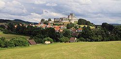
Rabí is a village and municipality (obec) in Klatovy District in the Plzeň Region of the Czech Republic.
Contents
Map of 342 01 Rab%C3%AD, Czechia
The municipality covers an area of 14.29 square kilometres (5.52 sq mi), and has a population of 468 (as at 2 October 2006).
Rabí lies approximately 28 kilometres (17 mi) south-east of Klatovy, 55 km (34 mi) south of Plzeň, and 106 km (66 mi) south-west of Prague.
History
Until 1918, the village was part of the Austrian monarchy (Austria side after the compromise of 1867), in the Strakonitz (Strakonice) district, one of the 94 Bezirkshauptmannschaften in Bohemia. A post-office was opened in 1869.
References
Rabí Wikipedia(Text) CC BY-SA