
Local time Wednesday 4:11 PM | Population 2,190 (2007) Team VV Raamsdonk | |
 | ||
Weather 13°C, Wind SE at 18 km/h, 46% Humidity | ||
Raamsdonk is a village in the Dutch province of North Brabant. It is located in the municipality of Geertruidenberg, about 15 km northeast of Breda.
Contents
Map of Raamsdonk, Netherlands
Toponymy
Raamsdonk (as "Dunc") is mentioned for the first time in 1253 as Ramesdunc and 1330 as Raemsdonc. A "dunc" or "dark" is a sand hill in a marshy area. The " Raams " prefix may indicate the presence of a certain type of plant, the wild garlic. However, it may also be the name of a person.
History
In 1609, the St. Lambert church fell into the hands of the Reformed Church. In 1611 came first pastor.
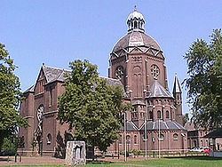
The Catholic people have been allowed in 1690 to establish a church in a barn, which was in the hamlet Waspikse the Benedenkerk. In 1787 was installed in Raamsdonk another church barn, which was dedicated to Saint-Bavo and was in Bergenstraat. In 1798, however, Catholics demanded to return to the St. Lambert church. What they did, but by paying a sum of money in compensation. The Church of the barn continued to serve until 1888. Then a new monumental St. Bavo Church, was built according to the plans of the architect Carl Weber. It is located in the present village .
At Raamsdonk until about 1850 existed a small french community, with among them a Graveline family, as well as Rotterdam around 1700 and Philippine in Zealand.
Raamsdonk was a separate municipality until 1997, when it became part of Geertruidenberg.