
Length 60 km Mouth Ibar | Basin size 1,193 km (461 sq mi) Country Serbia | |
 | ||
The Raška (Serbian Cyrillic: Рашка) is a river in southwestern Serbia, a 60 km-long left tributary to the Ibar river. Its historical name is Arzon (Greek: Αρζον).
Map of Raska, Serbia
The Raška originates from a strong well and several sinking streams flowing out from the cave south of the Sopoćani monastery, in the Pešter region. Waters of the well and the sinking streams flowing from the Koštan-Polje are gathered into the catchment which enabled construction of the small subterranean hydro electrical power plant Ras (6 MW).
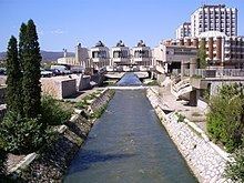
The Raška flows northward during the entirety of its flow and is received at the village of Pazarište the Sebečevačka reka from the right, between the villages of Dojeviće and Vatevo much longer Ljutska reka from the left and Jošanica from the right at the town of Novi Pazar, the most populous settlement on the river's course.
As it enters the Raška oblast, eastern part of the much larger Stari Vlah-Raška Region of the southwest Serbia, the river flows next to the old Petrova church and Novi Pazar's suburbs of Banja and Postenje. The lower course is not densely populated, except for the villages of Požežina and Milatkoviće. Finally, the river reaches the town of Raška and its suburb of Supnje, where it empties into the Ibar river.
The Raška drains an area of 1,193 km², belongs to the Black Sea drainage basin and it is not navigable.