
Population 245,328 (2015) | ||
 | ||
Weather 26°C, Wind E at 13 km/h, 91% Humidity Points of interest Đình Thần Nguyễn Trung Trực, Superdong Ticket office, Kien Giang Museum, Hải Đăng Hoa Biển, Thanh Giong Statue | ||
Crab noodles in rach gia vietnam
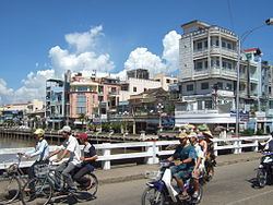
Rạch Giá ( listen) is a provincial city and the capital city of Kien Giang Province, Vietnam. It is located on the eastern coast of the Gulf of Thailand, 250 kilometres (160 mi) south-west of Ho Chi Minh City. East of city, it borders Tân Hiệp and Châu Thành town, the Gulf of Thailand is to the west and surrounds some parts of the city, south of the city is Châu Thành and An Biên town, northward it borders Hòn Đất and Tân Hiệp.
Contents
- Crab noodles in rach gia vietnam
- Map of RE1BAA1ch GiC3A1 Kien Giang Vietnam
- Administrative units
- Cultures and tourism
- Historic
- Transportation
- References
Map of R%E1%BA%A1ch Gi%C3%A1, Kien Giang, Vietnam
Administrative units
Rạch Giá was upgraded from a town to a city by Government Decree No. 97/2005/NĐ-CP on July 26, 2005. The city has 12 administrative units:
Rạch Giá is the first city where the Vietnamese government applied "lan bien" project to build out to the ocean to expand territory. "Lan bien" project expand the city to become one of the biggest new cities in the south-west of Vietnam. This project adds 2 more new wards in Rạch Giá. Beside that, several future construction projects such as industrial center Rach Vuot and urban city Vinh Hiep which will be started after finishing Lac Hong bridge project will expand Rạch Giá to the east.
Cultures and tourism
Ceremony of Nguyễn Trung Trực is held annually in lunar August.
Historic
National historical sites:
Other historical site:
Transportation
Rạch Giá has 2 main stations: Rach Soi station (main routes to neighbor towns or provinces on highway 61 and 63) and Rach Gia station (main routes to Ho Chi Minh City and Hà Tiên). Those are main stations to transport passengers to other towns in provinces or other provinces in nation.
Bus transportation system is developed pretty early, passengers can use bus from Rạch Giá to 4 other towns: Châu Thành (route Rạch Giá – Tac Cau), Giồng Riềng (route Rạch Giá – Giồng Riềng), Tân Hiệp (route Rạch Giá – Kinh B), Hòn Đất (route Rạch Giá – Tam Ngan).
Currently, Rach Gia Airport is the biggest airport in Rạch Giá. Rạch Giá airport has flight routes to Phú Quốc and Ho Chi Minh City with Vietnam Airlines.
Rạch Giá has 2 big ship stations: Rạch Giá ship station or Phú Quốc ship station (routes to Phú Quốc island and other big islands such as Phú Quốc, Hon Tre, Hon Son, Tho Chu…) and Rach Meo station (route to rural towns of Cà Mau Peninsula). High speed ship is economic choice for passengers to Phú Quốc island or Kiên Hải islands.