
Country Norway District Namdalen Area rank 44 in Norway Area 1,585 km² Local time Saturday 11:02 PM Official language form Norwegian Language | County Nord-Trøndelag Administrative centre Røyrvik Time zone CET (UTC+1) Population 499 (2011) Administrative center Røyrvik | |
 | ||
Weather 1°C, Wind W at 21 km/h, 95% Humidity | ||
Røyrvik (Southern Sami: Raarvihke) is a village and municipality in Nord-Trøndelag county, Norway. It is part of the Namdalen region. The administrative centre of the municipality is the village of Røyrvik. The area has always had a strong Sami influence.
Contents
- Map of 7898 RC3B8yrvik Norway
- General information
- Name
- Coat of arms
- Churches
- Geography
- Government
- Municipal council
- Economy
- References
Map of 7898 R%C3%B8yrvik, Norway
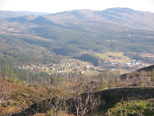
The 0.39-square-kilometre (96-acre) village of Røyrvik sits in the central part of the municipality and serves as the administrative center of the municipality. The village of Røyrvik has a population (2013) of 231, which gives it a population density of 592 inhabitants per square kilometre (1,530/sq mi).
General information
The municipality of Røyrvik was established on 1 July 1923 when it was separated from the municipality of Grong. Initially, the population was 392. The municipal boundaries have not since changed.
Name
The municipality (originally the parish) is named after the old Røyrvik farm (historically: Røirviken), since the first church, Røyrvik Church, was built there (in 1828). The first element is røyr which means Arctic char and the last element is vik which means "inlet".
Coat-of-arms
The coat-of-arms is from modern times; they were granted on 13 December 1985. The arms show a silver cross design on a blue background. This design is a common decoration on the pottery, hand-made articles, and traditional pewter embroidery found in the area. These objects were made by the ancestors of the Southern Sámi people presently living in the area. The crosses probably indicate the four points of the compass.
Churches
The Church of Norway has one parish (sokn) within the municipality of Røyrvik. It is part of the Namdal deanery in the Diocese of Nidaros.
Geography
The area is covered with many large lakes such as Limingen, the 9th largest in Norway. Other lakes include Jengelvatnet, Namsvatnet, Ovrejaevrie, Storgollomsvatnet, Tunnsjøen, and Tunnsjøflyan. The river Namsen begins in the lake Namsvatnet.
The mountainous areas also offer plentiful opportunities for outdoor activities. The highest mountain is the 1,513-metre (4,964 ft) tall Jetnamsklumpen, located inside Børgefjell National Park.
Government
All municipalities in Norway, including Røyrvik, are responsible for primary education (through 10th grade), outpatient health services, senior citizen services, unemployment and other social services, zoning, economic development, and municipal roads. The municipality is governed by a municipal council of elected representatives, which in turn elect a mayor.
Municipal council
The municipal council (Kommunestyre) of Røyrvik is made up of 13 representatives that are elected to every four years. Currently, the party breakdown is as follows:
Economy
From 1911 until World War I, mining explorations were conducted in the Gjersvik areas. The modern Grong Gruber mines were active in the Joma area from 1972 until 1998. Farming and reindeer husbandry have always been a source of income in the area. The mining buildings now house various small industrial firms.
A few efforts to create new business include electronics assembly and electronic document management. A small alpine ski resort (Skisenteret) was started in 1986.