
Surface area 6.99 km (2.70 sq mi) Surface elevation 380 m Shore length 20.64 km | References NVE Area 6.99 km² | |
 | ||
Max. length 8.8 kilometres (5.5 mi) Max. width 1.3 kilometres (0.81 mi) Reference Norwegian Water Resources and Energy Directorate | ||
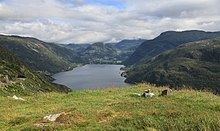
Røldalsvatnet is a lake in the municipality of Odda in Hordaland county, Norway. The 6.99-square-kilometre (2.70 sq mi) lake is located about 35 kilometres (22 mi) south of the town of Odda. The village of Røldal is located at the northern tip of the lake and the village of Botnen is located at the southern end. The European route E134 highway runs along the northern end of the lake, and the Norwegian National Road 13 runs along the western shore of the lake.
Map of R%C3%B8ldalsvatnet, 5760 R%C3%B8ldal, Norway
References
Røldalsvatnet Wikipedia(Text) CC BY-SA