
Basin size 38.18 sq mi (98.9 km) Source elevation 1,250 m Mouth elevation 0 | River system Río Inabón Length 32 km | |
 | ||
River mouth Caribbean Sea0 feet (0 m) Progression AnónRealCoto LaurelCapitanejo | ||
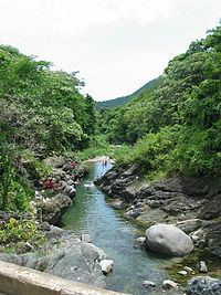
Río Inabón is a river in the municipality of Ponce, Puerto Rico. With a length of some 32.01 kilometers (19.89 mi), it is Ponce's second longest river after Río Jacaguas. It is fed by the Río Anón, Río Guayo (which itself is fed by the Chiquita Brook and the Indalecia Brook) and the Emajagua Brook. It is also fed by Río Bacas and Río de las Raices. This river is one of the 14 rivers in the municipality. Originating at an altitude of approximately 4,100 feet (1,200 m), it forms at the highest point of any other river in the municipality, and at one of the highest points of any river in Puerto Rico. With a watershed area covering 38.18 square miles, Río Inabon also has the second largest basin area of any of the municipality's 14 rivers after Rio Jacaguas.
Contents
- Map of RC3ADo InabC3B3n Puerto Rico
- Origin and courseEdit
- UsesEdit
- Environmental contaminationEdit
- Endangered speciesEdit
- FlowEdit
- References
Map of R%C3%ADo Inab%C3%B3n, Puerto Rico
Origin and courseEdit
Río Inabon has its origin at 4,100 feet (1,200 m) above sea level in Cerro Camacho, in barrio Anón, near Anon's boundary with the municipality of Jayuya. The river runs mostly parallel to PR-511.
UsesEdit
"A provision in The Treaty of Paris of 1898 grants the Serrallés family exclusive rights to the Río Inabón. This river winds through Puerto Rico’s volcanic mountains, and is the exclusive water source for DonQ Rum". Today Río Inabón is one of the most popular rivers for swimming in southern Puerto Rico. Some 10 private reservoirs in the Ponce area are fed by the waters of Río Inabón.
Environmental contaminationEdit
In January 2011, Puerto Rico Representative Víctor Vassallo Anadón presented a bill into the Puerto Rico House of Representatives that would improve the sewer system of residents near the river to avoid contaminating it with sewer waters.
Endangered speciesEdit
The fern Thelypteris inabonensis found at the headwaters of Río Inabon and at the Toro Negro State Forest has been identified by the U.S. Fish and Wildlife Service as an endangered species.
FlowEdit
The flow of water in the river is controlled by the floodgates at Toa Vaca Lake, located in the municipality of Villalba. Río Inabon has a discharge of 15,000 ft3/s The Inabón has been known to overflow easily in times of heavy rains. Several rescues have taken place when the river has increased its level rapidly, a phenomenon known as flash flood. Due to its proximity to the eastern end of Aeropuerto Mercedita, the river has affected the operation of the airport in times of heavy rains. This was the case with the hurricane Maria in September 2011.