
Demonym(s) riocabellense CPA base X5111 Elevation 729 m | Time zone ART (UTC-3) Dialing code +54 3543 Local time Saturday 4:38 PM | |
 | ||
Weather 24°C, Wind NE at 18 km/h, 65% Humidity | ||
Rally argentino r o ceballos villa allende unquillo 2014 p e 2 ascochinga agua de oro ii
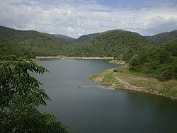
Río Ceballos is a city and tourist destination in the Province of Córdoba located in the center of Argentina. Río Ceballos is located at the foot of the Sierras Chicas, about 30 km north of the provincial capital of Córdoba and is part of the Greater Córdoba area. Río Ceballos is accessed from Córdoba by taking Route E-53 north passing the Airport or by Cordoba City through Villa Allende, Mendiolaza and Unquillo, vía Route E-57. The Natural Hydrologic Reserve "La Quebrada Park" ("Parque La Quebrada") is 7 km beyond Río Ceballos taking the San Martin Avenue till its end.
Contents
- Rally argentino r o ceballos villa allende unquillo 2014 p e 2 ascochinga agua de oro ii
- Map of Rio Ceballos CC3B3rdoba Argentina
- References
Map of Rio Ceballos, C%C3%B3rdoba, Argentina
Río Ceballos had 16,632 inhabitants according to the 2001 census, representing an increase of 29.9% over the population counted for the 1991 census. It has the fourth largest population of cities in the Greater Córdoba area.