
Arabic قولة Also spelled Kouleh Cola, Chola Palestine grid 146/160 Local time Tuesday 9:15 PM | Name meaning from a personal name Date of depopulation 10 July 1948 | |
 | ||
Weather 14°C, Wind N at 8 km/h, 83% Humidity | ||
Ramlila on lal qula delhi first day ganesh puja and guru bashisht muni in darbar of raja dashrath
Qula (Arabic: قولة, Hebrew: קולה) was a Palestinian village in the Ramle Subdistrict of Mandatory Palestine. It was located 15 km northeast of Ramla and was depopulated during the 1948 Arab-Israeli war.
Contents
- Ramlila on lal qula delhi first day ganesh puja and guru bashisht muni in darbar of raja dashrath
- History
- Ottoman era
- British Mandate era
- 1948 war and aftermath
- References
Hasan Salama and his son Ali Hassan Salameh (1940-1979) were from Qula.
History
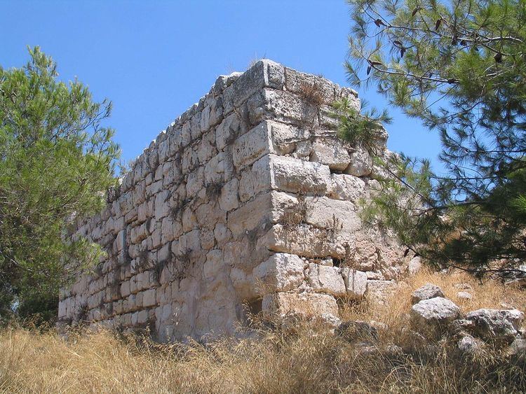
During the twelfth century the Hospitallers established an administrative and collection centre in the village, comprising a tower and a vaulted structure.
Ottoman era
In 1596, Qula was part of the Ottoman Empire, nahiya (subdistrict) of al-Ramla under the Liwa of Gaza, with a population of 380. It paid taxes on goats and beehives, and a press that was used for processing either olives or grapes.
In 1870, the French explorer Victor Guérin visited, and an Ottoman village list from about the same year showed Kula with a population of 159, in 38 houses, though the population count included men only.
In 1882, the Palestine Exploration Fund's Survey of Western Palestine (SWP) the village of Qula was described as being situated on a slope at the edge of a plain; its historical relics dating back to medieval times. The SWP also noted ancient remains.
The village mosque stood approximately 10m east of the Crusader tower. It comprised a large vaulted iwan and a smaller room with an inscription above the entrance.
British Mandate era
During the British mandate period, the village expanded along the Ramle-Tulkarm highway. In the village center was the mosque, several small shops, and a school which had been founded in 1919. By the mid-1940s the school had 134 students.
In the 1922 census of Palestine, Quleh had a population of 480 inhabitants, all Muslims, increasing in the 1931 census to 697, still all Muslims, in a total of 172 houses.
In 1945 the population was 1,010, all Muslims, while the total land area was 4,347 dunams, according to an official land and population survey. Of this, a total of 2,842 dunums of land was used for cereals, 105 dunums were irrigated or used for orchards, while 26 dunams were classified as built-up areas.
1948 war and aftermath
Most of the villagers fled in 1948, leaving only a few, primarily elderly behind. The villagers from Qula report that those left behind (six women and one man) were all shot or burned to death in their homes.
The Palestinian historian Walid Khalidi described the village site in 1992: "A forest covers much of the village site. The rubble of crumbled houses and terraces lies among the trees, and cactuses and fig, mulberry, and eucalyptus trees grow there as well. The only remaining landmark is the school, on the west side of the site. The hilly parts of the surrounding land are used for grazing animals; the rest of the land is cultivated.