
Part of NY 25 Maintained by NYCDOT | Length 7.5 mi (12.1 km) | |
 | ||
Nearest metro station Flushing Line Queens Boulevard Line Jamaica–Van Wyck | ||
The transformation of queens boulevard block by block
Queens Boulevard is a major thoroughfare in the New York City borough of Queens connecting Midtown Manhattan, via the Queensboro Bridge, to Jamaica. It forms part of New York State Route 25.
Contents
- The transformation of queens boulevard block by block
- Map of Queens Blvd Queens NY 11373 USA
- Archie star queens boulevard lyrics
- Route description
- History
- Transportation
- Boulevard of Death reputation
- In popular culture
- References
Map of Queens Blvd, Queens, NY 11373, USA
Archie star queens boulevard lyrics
Route description
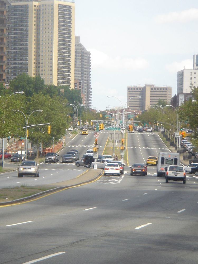
Queens Boulevard runs northwest to southeast across a little short of half the length of the borough, starting at Queens Plaza at the Queensboro Bridge entrance in Long Island City and running through the neighborhoods of Sunnyside, Woodside, Elmhurst, Rego Park, Forest Hills, Kew Gardens, and Briarwood before terminating at Jamaica Avenue in Jamaica. At 7.5 miles (12.1 km), it is one of the longest roads in Queens, and it runs through some of Queens' busiest areas. Much of the road is 12 lanes wide, and at its intersection with Yellowstone Boulevard in Forest Hills, it reaches a high point of 16 lanes. Along much of its length (between Roosevelt Avenue and Union Turnpike), the road includes six express lanes (three in each direction) and a three-lane-wide service road on each side. Drivers must first exit to the service road in order to make right turns or pull over; left turns must be made from the express lanes, but only at select cross-streets. It is known as the Boulevard of Death. More crashes happen along Queens Boulevard than any other roadway statewide.
Queens Boulevard is also the starting point of a number of the other major streets in Queens, such as Northern Boulevard, Woodhaven Boulevard, Junction Boulevard, Roosevelt Avenue, and Main Street.
History
The route of today's Queens Boulevard originally consisted of Hoffman Boulevard and Thompson Avenue, which was created by linking and expanding these already-existing streets, stubs of which still exist. A remnant of the old Hoffman Boulevard can be found in Forest Hills where the local lanes of traffic diverge into two routes, one straight and one that bends around MacDonald Park. The part that bends around the park was the original route of Hoffman Boulevard. The street was built in the early 20th century to connect the new Queensboro Bridge to central Queens, thereby offering an easy outlet from Manhattan.
In 1913, a trolley line was constructed from 59th Street in Manhattan east along the new boulevard. During the 1920s and 1930s the boulevard was widened in conjunction with the digging of the IND Queens Boulevard Line subway tunnels in the 1920s and 1930s. The new subway line used cut-and-cover construction and trenches had to be dug up in the center of the thoroughfare, and to allow pedestrians to pass over the construction, temporary bridges were built. The improvement was between Van Dam Street and Hillside Avenue, and it cost $2,230,000. The street was widened to 200 feet between Van Dam Street and Union Turnpike, and from there to Hillside Avenue it was widened to 150 feet. As part of the project, there was to have been separated rights-of-way for the trolley line. On April 17, 1937, trolley service along Queens Boulevard ended, being replaced by bus service. In 1941, the New York City Planning Department proposed converting it into a freeway, as was done with the Van Wyck Expressway from the Queensboro Bridge to Hillside Avenue. The boulevard would be converted to an expressway with grade separation at the more important intersections, and by closing off access from minor streets. As part of the project, the express lanes of Queens Boulevard were depressed in the area of Woodhaven Boulevard and Horace Harding Boulevard (later turned into the Long Island Expressway), while the local lanes were kept at grade level. The plan to upgrade the boulevard was delayed with the onset of World War II, the plan was never completed.
Transportation
This street hosts one of the highest numbers of New York City Subway services in the city. The E F M R (IND Queens Boulevard Line) and the 7 <7> N W (IRT Flushing Line) all use stretches of the right of way; only Broadway (eight services), Sixth Avenue (seven) in Manhattan and Fulton Street (eight) in Brooklyn carry more at any one time. In addition, the Q60 bus travels its entire length, and the Q32 and Q59 buses travel for significant portions of the boulevard's length.
For a few decades streetcar service operated along the boulevard and until 1957 operated along the sides of the Queensboro Bridge into Manhattan. For the section where the line ran congruent with the Flushing IRT elevated line the streetcars ran in a median below the viaduct supporting the elevated trains. In the space of the present-day Aviation High School, there was a train yard for the streetcars.
Boulevard of Death reputation
The combination of Queens Boulevard's immense width, heavy automobile traffic, and thriving commercial scene made it by the 1990s the most dangerous thoroughfare in New York City and has earned it city-wide notoriety and morbid nicknames such as "The Boulevard of Death" and "The Boulevard of Broken Bones." Its width is comparable to that of Ocean Parkway and Linden Boulevard in Brooklyn; the Grand Concourse and Bruckner Boulevard in the Bronx; Richmond Avenue in Staten Island; and Park Avenue and Delancey Street in Manhattan. Some of the most dangerous crossings of Queens Boulevard are near Roosevelt Avenue, 51st Avenue, Grand Avenue, Woodhaven Boulevard, Yellowstone Boulevard, 71st Avenue, and Union Turnpike, due to the fact that most of these streets cross the boulevard diagonally.
Between 1980 and 1984, at least 22 people died and 18 were injured in a 2.5-mile (4.0 km) stretch of Queens Boulevard. In 1985, the New York City Department of Transportation started a project to examine the causes of fatalities and injuries on the boulevard. From 1993 to 2000, 72 pedestrians were killed trying to cross the street, or an average of 10 per year. In January 1997, the city commissioned a study of the 2.5 miles (4.0 km) of roadway between the Long Island Expressway and Union Turnpike. The study was completed by 1999, and most work was finished by July 2001. As part of the improvement process, the city installed new curb- and median-extensions along the corridor; repainted crosswalks so they were more visible; added fences in the medians; closed several "slips" that allowed vehicles to make high-speed turns; improved streetlights, traffic signals, and pedestrian signals; posted large signs proclaiming that "A Pedestrian Was Killed Crossing Here" at intersections where fatal accidents have occurred; and reduced the speed limit from 35 to 30 miles per hour (56 to 48 km/h). A second phase covering the rest of the boulevard was studied from November 2001 to July 2004, and improvements were finished by late 2006. These improvements decreased pedestrian accidents on the boulevard by 68%, most notably at large and dangerous intersections. In 2004, only one pedestrian was killed crossing Queens Boulevard.
In 2011, safety enhancements, including pedestrian "countdown" signals that count the time left to cross the street, were implemented. That year was the first year that no one was killed crossing the street. In 2015, a new initiative was announced to further improve Queens Boulevard at a cost of $100 million. The section between Roosevelt Avenue and 73rd Street received new safety improvements, including pedestrian zones and bike lanes, as part of improvement's Phase 1, which began in August 2015 and was finished by the end of the year. Phase 2 began in summer 2016, while Phase 3 is expected to begin in 2017. All three phases are to be completed by 2018, and the whole boulevard will eventually be totally overhauled in a manner similar to the Grand Concourse's capital reconstruction.