
Length 185 km (115 mi) N/S Area 12,000 km² | Width 73 km (45 mi) E/W Elevation 2,364 m | |
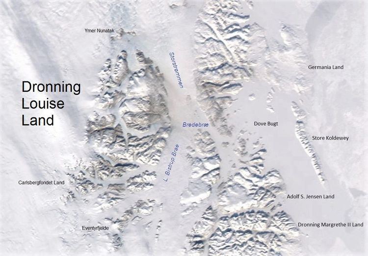 | ||
Queen Louise Land (Danish: Dronning Louise Land; Greenlandic: Nuna Dronning Louise) is a vast mountainous region located west of Dove Bay, King Frederick VIII Land, northeastern Greenland. Administratively it is part of the Northeast Greenland National Park zone.
Contents
The highest point of Queen Louise Land is Gefiontinde, with a height of 2,364.3 m (7,757 ft), the highest of the Gefiontinder group of peaks located at 76°28′8″N 25°38′31″W.
Geologically Queen Louise Land is made up of orthogneiss overlain by sedimentary rocks.
History
This remote area was named Dronning Louises Land after Queen Louise of Sweden (1851–1926), wife of King Frederick VIII of Denmark, by the ill-fated 1906–08 Denmark Expedition —the expedition that aimed to map one of the last unknown parts of Greenland. Danish Arctic explorer Alf Trolle claimed that this area had been originally named as Den Store Nanuták —The Big Nunatak.
Queen Louise Land was subsequently visited by the 1912–13 Danish Expedition to Queen Louise Land led by J.P. Koch, as well as the 1952–54 British North Greenland Expedition led by Commander James Simpson.
Geography
Surrounded by ice masses, Queen Louise Land is clearly delimited. It is an extensive area made up of several very large and numerous small nunataks. Its western boundary is the Greenland ice sheet and its western limits are the massive Storstrommen and L. Bistrup Brae glaciers. Kap Aage Bertelsen is a small headland at the confluence of the large Storstrømmen and L. Bistrup Bræ glaciers in the east. Dryasdal is a valley seasonally covered with Dryas octopetala flowers. The area of Queen Louise Land is uninhabited.
The main geographic divisions or parts of Queen Louise Land from north to south are:
Mountains, nunataks and cliffs
Many of the mountains and massifs are little glaciated; mountains are generally rounded and rarely craggy. There are numerous cliffs though. The average elevation is around 1,500 m.