
Country United States County Windsor Area code(s) 802 Elevation 177 m Population 656 (2010) | Time zone Eastern (EST) (UTC-5) FIPS code 50-57775 Zip code 05059 Local time Tuesday 1:28 AM | |
 | ||
Weather 0°C, Wind N at 6 km/h, 68% Humidity | ||
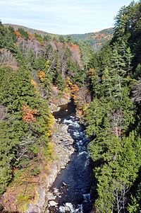
Quechee gorge quechee vermont
Quechee is a census-designated place and one of five unincorporated villages in the town of Hartford, Windsor County, Vermont, United States. As of the 2010 census, the population of the CDP was 656. It is the site of Quechee Gorge on the Ottauquechee River and is also the home to the Quechee Lakes planned community initiated in the late 1960s, which also brought to the community the small Quechee Lakes Ski Area in the 1970s.
Contents
Map of Quechee, Hartford, VT, USA
Quechee was known for a picturesque covered bridge at the site of the old Quechee mill, which now houses the Simon Pearce glass-blowing facility and restaurant. The bridge was severely damaged by flooding caused by Hurricane Irene in 2011. The bridge has since been rebuilt.
Quechee has a small branch post office with zip code 05059.
Geography
Quechee is located along the Ottauquechee River in the western part of the town of Hartford. U.S. Route 4 passes through the CDP, just south of the village center, connecting with Woodstock and Rutland to the west and with White River Junction to the east. Quechee Gorge forms the southeastern edge of the CDP.