
State Kingdom of Denmark Municipality Qaasuitsup Area 659,999 km² Capital Ilulissat Date formed January 1, 2009 | Established 1 January 2009 Time zone UTC-03, UTC-04 Population 17,498 (2013) Area code +299 Team Nagdlunguaq-48 | |
 | ||
Points of interest Knud Rasmussen's Museum, Jakobshavn Glacier, Petermann Glacier, Uummannaq, Ilulissat Glacier | ||
Qaasuitsup (Greenlandic: Qaasuitsup Kommunia, "Place of Polar Darkness") is a municipality in Greenland, operational from 1 January 2009. As of January 2013 its population is 17,498. The administrative center of the municipality is in Ilulissat (formerly called Jakobshavn). The municipality consists of the former municipalities of western and northern Greenland, each named after the biggest settlement:
Contents
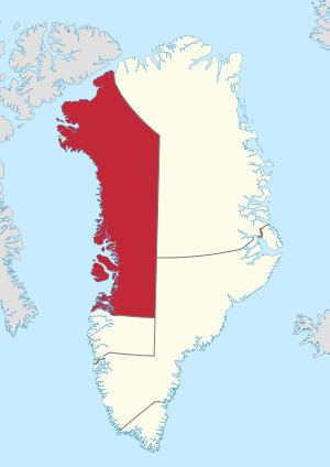
Map of Qaasuitsup Municipality, Greenland
Geography
The municipality is located in northwestern Greenland. With an area of 660,000 km2 (254,827.4 sq mi), it is the largest municipality in the world by area, larger than France at 643,427 km2 (248,428.6 sq mi).
In the south, it is flanked by the Qeqqata municipality. In the southeast, it is bordered by the Sermersooq municipality, however this border runs north-south (45° West meridian) through the center of the Greenland ice sheet (Greenlandic: Sermersuaq), and as such is free of traffic. In the east and northeast it is bordered by the Northeast Greenland National Park.
At the southern end of the municipal coastline are the waters of Disko Bay, an inlet of the larger Baffin Bay, which to the north edges into the island of Greenland in the form of Melville Bay. The coastline of northeastern Baffin Bay is dotted with islands of the Upernavik Archipelago, entirely contained within the municipality. In the far northwest near Qaanaaq and Siorapaluk, the municipal shores extend into Nares Strait, which separates Greenland from Ellesmere Island.
Denmark claims Hans Island as part of Qaasuitsup, while Canada considers it to be part of the Nunavut region of Qikiqtaaluk.
Towns and settlements
Language
Kalaallisut, the West Greenlandic dialect, is spoken in the towns and settlements of the western and northwestern coasts. Inuktun is also spoken in and around Qaanaaq.