
Time zone EET (UTC+2) Local time Thursday 10:55 PM | Founded ca. 1380 Municipal tax rate 19.75% | |
 | ||
Area rank 228th largest in Finland Weather -1°C, Wind SW at 11 km/h, 59% Humidity | ||
Pyhtää (Swedish: Pyttis) is a municipality of Finland.
Contents
Map of 49270 Pyht%C3%A4%C3%A4, Finland
Overview
It is located in the Kymenlaakso region. The municipality has a population of 5,306 (31 March 2016) and covers an area of 324.75 square kilometres (125.39 sq mi) of which 456.24 km2 (176.16 sq mi) is water. The population density is 16.34 inhabitants per square kilometre (42.3/sq mi).
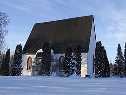
The medieval church (as opposed to the municipality) is situated in the village of Itäkirkonkylä ("East Church Village"). During the Reformation, the rather beautiful and moving pictures on the walls were whitewashed over. Some years ago, they were rediscovered and the whitewash removed. The village lies just to the East of the westernmost tributary of the Kymi River and was at one time on the border between Russia and Sweden established by the Treaty of Åbo in 1743. Indeed, on the Western side of the river is a municipality called Ruotsinpyhtää ("Swedish Pyhtää") known as Strömfors in Swedish.
The municipality is bilingual with 7,001,883,000,000,000,000♠88.3% speaking Finnish, 7,000,960,000,000,000,000♠9.6% Swedish and 7,000,210,000,000,000,000♠2.1% other languages as their first language.