
Primary inflows Max. length 28 km (17 mi) Surface area 327 km (126 sq mi) Area 327 km² Length 28 km | Max. width 12 km (7 mi) Average depth 1–2 m (3.3–6.6 ft) Mean depth 1 m Outflow location Indian Ocean | |
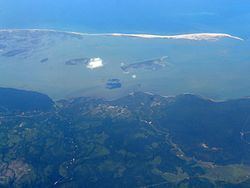 | ||
Sri lanka puttalam lagoon view
The Puttalam Lagoon is a large 327 km2 (126 sq mi) lagoon in the Puttalam District, western Sri Lanka.
Contents
Map of Puttalam Lagoon, Sri Lanka
The lagoon is fed by two rivers, namely the Kala Oya and Mi Oya, discharging at 2.2 m3/s (77.7 cu ft/s) and 8.1 m3/s (286.0 cu ft/s) respectively. It is linked to Mundal Lagoon 15 km (9.3 mi) to the south by a channel. The lagoon's water is brackish to saline.
The lagoon is surrounded by a region containing coconuts, open forests, grasslands and shrublands. The land is used for prawn fishing, salt production, and rice cultivation. The lagoon has extensive mangroves, seagrasses and some salt marshes, attracting a wide variety of anatidae.
Islands
A moderate number islands scatter over the lagoon including:
References
Puttalam Lagoon Wikipedia(Text) CC BY-SA