
Time zone CET (UTC+1) Area 48.93 km² Local time Thursday 5:23 PM | County Csongrád Postal code 6769 Population 1,674 (2002) Area code 62 | |
 | ||
Weather 18°C, Wind NE at 8 km/h, 42% Humidity | ||
Pusztaszer is a village in Csongrád county, in the Southern Great Plain region of southern Hungary.
Contents
Map of Pusztaszer, 6769 Hungary
Geography
It covers an area of 48.93 km2 (19 sq mi) and has a population of 1674 people (2002).
Sightseeing
A National Memorial Park has been erected in the neighborhood of the village to remember the first parliamentary meeting of Hungarians in 895-896. In a great hall the circular panorama painting of Árpád Feszty was rebuilt and related exhibitions form an important national museum of Hungary.
In the Memorial Park a village museum has been also rebuilt (Skanzen). There old buildings once popular in the Great Hungarian Plain can be visited together with old workshops. For example the old car factory consisted of the three workshops of the wheel-maker, the ladder-mount maker and the blacksmith masters.
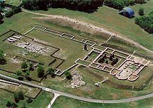
The ruins of an old Benedictine monastery of Romanesque style was also excavated in Pusztaszer. The foundations can be visited and the western doorway is partly reconstructed.
Sculptures of old Hungarian kings and princes form a historical sculptural memorial garden.