Harman Patil (Editor)

Pushpagiri (mountain)

Updated on
Edit
Like
Comment
Share on FacebookTweet on TwitterShare on LinkedInShare on Reddit
Location
  
Easiest route
  
Hike

Mountain range
  
Parent range
  
Elevation
  
1,748 m

Pushpagiri (mountain) bmcindiaorgeventskp4jpg

Similar
  
Tadiandamol, Brahmagiri (hill) - Karnataka, Kodachadri, Mullayanagiri, Baba Budangiri

Pushpagiri or Kumara Parvatha, at 1,712 metres (5,617 ft), is the highest peak in Pushpagiri Wildlife Sanctuary in the Western Ghats of Karnataka. It is located in the Somwarpet Taluk, 20 kilometres (12 mi) from Somwarpet in the northern part of Kodagu district on the border between Dakshina Kannada and Kodagu district and hassan districts. It is 6th highest peak of Karnataka.

Contents

Map of Kumara Parvatha, Kumaralli, Karnataka 571236

Pushpagiri | Hiking to the land of unknown | stone shrines


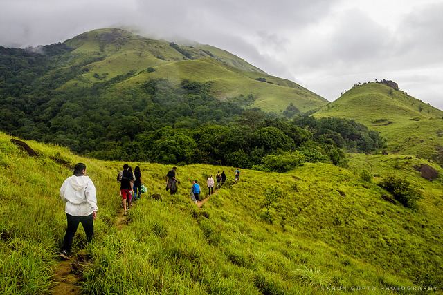
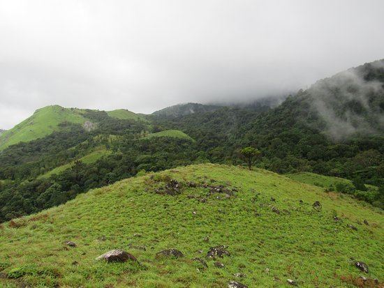
Pushpagiri Mountains

The Pushpagiri or Subramanya Hills (also referred as Kumaraparvatha) is the second-highest peak of Kodagu, and sixth highest peak in Karnataka

About 36 kilometres (22 mi) from Somwarpet and 1.5 kilometres (0.93 mi) from Kumaralli, it is located amid the jungle. Trekking can be done from the base, Bhagati, which is a 10 km, three-hour walk. Otherwise, trekkers can cross Kukke Subramanya, located in Dakshina Kannada district of Pushpagiri Range. The trekking zone can be approached from Pushpagiri or from Kumaraparvata peaks.

The Eastern entrance can be reached from Beedehalli via Heggademane temple and the Western entrance from Kukke Subramanya via Giri gadde. However, the entrance through Beedehalli is less strenuous.

The entrance from Kukke Subramanya is located the sea level.

Demography

Pushpagiri Wildlife Sanctuary (Coorg) - 2020 What to Know Before You Go  (with Photos) - Tripadvisor

  • Somwarpet
  • As of the 2001 India census, Somwarpet had a population of 7218. Males constitute 50% of the population and females 50%. Somwarpet has an average literacy rate of 75%, higher than the national average of 59.5%: male literacy is 80%, and female literacy is 70%. In Somwarpet, 12% of the population is under 6 years of age.Somwarpet is located at 10.42°N 74.73°E / 10.42; 74.73 It has an Elevation of 1525 metres (5003 feet).
  • Madikeri
  • As of 2001 India census, Madikeri had a population of 32,286. Males constitute 51% of the population and females 49%. Madikeri had an average literacy rate of 81%, higher than the national average of 59.5%: male literacy was 83%, and female literacy 79%. 11% of the population was under 6 years of age. This town is situated at an elevation of over 5000 ft above sea level.Madikeri is located at 12.42°N 75.73°E / 12.42; 75.73 It has an elevation of 1525 metres (5003 feet).
  • Kushalanagara
  • As of 2001 India census, Kushalnagar had a population of 13,262. Males constitute 53% of the population and females 47%. Kushalnagar has an average literacy rate of 78%, higher than the national average of 59.5%: male literacy is 82%, and female literacy is 73%. In Kushalnagar, 12% of the population is under 6 years of age.Kushalnagar is located at 12.47°N 75.97°E / 12.47; 75.97 It has an average elevation of 831 metres (2726 feet).

    Climatic conditions

    The climate is generally cool and wet. The climate is that of a highland, with no extreme variations. It receives heavy rainfall between June to September. From October to December the area is covered in mist almost all the time.

  • Rainfall: The rainfall in Coorg varies extensively, ranging from 3,500 mm (140 in) per year in the western Highlands and to under 1,000 mm (40 in) per year near the eastern plateau.
  • Temperature: November to January are generally the coldest months, with the daytime maximum temperatures that ranges of an average of around 7° to 20 °C. April and May are normally the warmest months here, with temperatures of an average 29 °C. The temperatures in Mercara and Virajpet are generally a few degrees cooler than in Kushalnagar because of the hilly terrace.
  • Visibility: This place often enjoys good visibility, although hill fog sometimes restricts the visibility.
  • References

    Pushpagiri (mountain) Wikipedia


    Similar Topics