
Type Natural Reference 1094 Inscription 2003 (27th Session) Phone +61 8 9168 7300 | Criteria vii, viii UNESCO region Asia-Pacific Area 2,397 km² Established 1987 | |
 | ||
Location East Kimberley region, Northern Australia Similar Bungle Bungle Wilderne, The Bungle Bungles, Bungle Bungle Caravan, Walardi Campsite, Bungle Bungle Expeditio | ||
The Purnululu National Park is a World Heritage Site in the East Kimberley region of Western Australia. The 239,723-hectare (592,370-acre) national park is located approximately 300 kilometres (190 mi) south of Kununurra, with Halls Creek located to the south. Declared a World Heritage Site in 2003, the park was inscribed as follows:
Contents
- Australia purnululu national park
- Purnululu National Park World Heritage site
- Etymology
- Features
- Geology
- Access
- References
Australia purnululu national park
Purnululu National Park World Heritage site
The World Heritage status of the region was created and negotiated in 2003, and the adopted boundary of the existing national park. Since its listing, the Government of Western Australia has reserved additional areas located adjacent to the World Heritage Area, including the Purnululu Conservation Park and the Ord River Regeneration Reserve. The site was gazetted on the Australian National Heritage List on 21 May 2007 under the Environment and Heritage Legislation Amendment Act (No. 1), 2003 (Cth).
Etymology
Purnululu is a mispronounced Djaru word for the area around Bungle Bungle out camp, which is referred to as Bullmanlulu. The correct Karjaganujaru name for the Bungle Bungle massif is Billingjal which means sand falling away.
The traditional owners of the area are the Karjaganujaru peoples.
Features
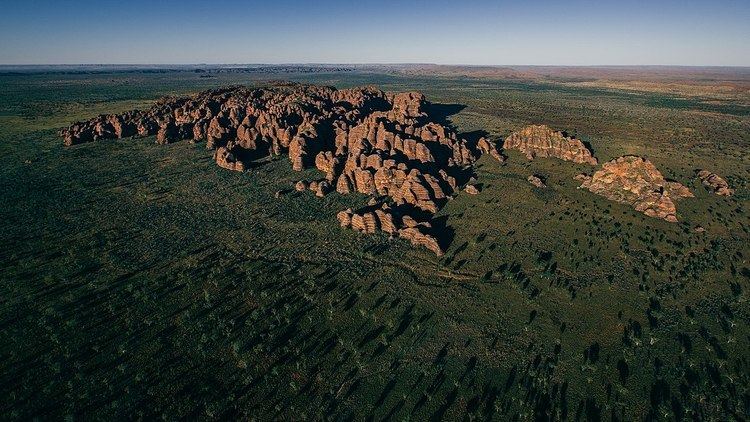
The Bungle Bungle Range, lying fully within the park, has elevations as high as 578 metres (1,896 ft) above sea level. It is famous for the sandstone domes, unusual and visually striking with their striping in alternating orange and grey bands. The banding of the domes is due to differences in clay content and porosity of the sandstone layers: the orange bands consist of oxidised iron compounds in layers that dry out too quickly for cyanobacteria to multiply; the grey bands are composed of cyanobacteria growing on the surface of layers of sandstone where moisture accumulates.
Geology
The Bungle Bungle Range is one of the most extensive and impressive occurrences of sandstone tower (or cone) karst terrain in the world. The Bungle Bungles were a plateau of Devonian sandstone, carved into a mass of beehive-shaped towers with regularly alternating, dark gray bands of cynobacterial crust (single cell photosynthetic organisms). The plateau is dissected by a 100–200-metre (330–660 ft) deep, sheer-sided gorges and slot canyons. The cone-towers are steep-sided, with an abrupt break of slope at the base and have domed summits. How they were formed is not yet completely understood. Their surface is fragile but stabilized by crusts of iron oxide and bacteria. They provide an outstanding example of land formation by dissolutional weathering of sandstone, with removal of sand grains by wind, rain and sheet wash on slopes.
Access
Access to the park by road is via Spring Creek Track, from the Great Northern Highway approximately 250 kilometres (160 mi) south of Kununurra, to the track's end at the visitor centre. The track is 53 kilometres (33 mi) long and is usable only in the dry season (about 1 April to 31 December) by four-wheel-drive (4WD) vehicles. Safely navigating it takes approximately three hours. Access by air is less demanding; helicopter flights are available from Bellburn Airstrip in the national park, and from Warmun roadhouse. Scenic light aircraft flights are also available out of Kununurra and Lake Argyle.