
Progression Arkansas—Mississippi Length 315 km Mouth Arkansas River Cities Las Animas, Weston | Basin size 3,447 sq mi (8,930 km) Basin area 8,930 km² Country United States of America | |
 | ||
Main source Confluence of North Fork and Middle Fork River mouth Confluence with Arkansas
3,862 ft (1,177 m) Sources North Fork Purgatoire River, Middle Fork Purgatoire River | ||
Homesteading landscape of southeast colorado s purgatoire river region q a
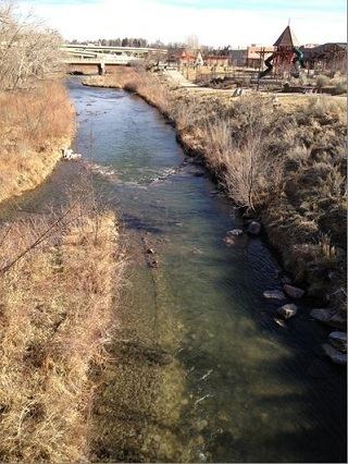
The Purgatoire River is a river in southeastern Colorado, United States. The river is also known locally as the Purgatory River or the Picketwire River. Purgatoire means Purgatory in French. French trappers named the river to commemorate Spanish explorers killed in a Native American attack.
Contents
- Homesteading landscape of southeast colorado s purgatoire river region q a
- Map of Purgatoire River Colorado USA
- References
Map of Purgatoire River, Colorado, USA
The Purgatoire River originates at the confluence of the North Fork Purgatoire and Middle Fork Purgatoire rivers near Weston in Las Animas County, Colorado, and flows generally east-northeastward approximately 196 miles (315 km) to a confluence with the Arkansas River in John Martin Reservoir State Park near Las Animas in Bent County, Colorado. The Purgatoire River drains an area of 3,447 square miles (8,930 km2). 96.4% of this area is in Colorado, the remaining 3.6% is in New Mexico.
The Piñon Canyon Maneuver Site is a large military base located along the western bank of the Purgatoire River. Plans by the U.S. Army to expand the base have been controversial. Citizens' groups have succeeded in stopping the planned expansion as of 2011.
The river is frequently referred to as the Picketwire in the film The Man Who Shot Liberty Valance. This is a folk-etymologizing anglophone phonological approximation of the French pronunciation /pyʁ.ɡa.ˡtwaʁ/, developed by English-speaking settlers who later came to the area.