
Settled 1965 Highest elevation 160 m (520 ft) Local time Wednesday 5:01 PM | Canton Puerto Quito Established April 1, 1996 Lowest elevation 120 m (390 ft) | |
 | ||
Weather 26°C, Wind NW at 8 km/h, 91% Humidity | ||
A visit to luna huasi puerto quito ecuador
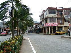
Puerto Quito is a town and urban parish in the province of Pichincha, Ecuador. The town is a developing area for eco-tourism, thanks to an abundance of wildlife, secondary jungle and beautiful waterfalls such as the Cascada Azul (Blue Waterfall). Puerto Quito is situated beside a major bridge over the river Caoní on the main road from Quito to the coast. By road, Quito is 140 km or 3.5 hours by bus.
Contents
- A visit to luna huasi puerto quito ecuador
- Map of Puerto Quito Ecuador
- Geography and climate
- References
Map of Puerto Quito, Ecuador
Geography and climate
Although geographically part of the Sierra region of Ecuador, Puerto Quito's climate and geography is closer to that of the coastal region. The town is located in the tropical forest of Ecuador. As such, it has a higher temperature than the rest of the province, averaging around 25 degree celsius year-round. Average rainfall is between one and two meters a year.