
Elevation 2,400 m | ||
 | ||
Similar Chimantá Massif, Karaurín‑tepui, Ilú–Tramen Massif, Uei‑tepui, Cerro Duida | ||
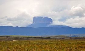
Ptari-tepui, also spelled Pu-tari and sometimes called Cerro Budare or Cerro del Budare, is a tepui in Bolívar state, Venezuela. Lying near the centre of the Sierra de Lema, it has a maximum elevation of around 2,400 metres (7,900 ft) above sea level. Its mostly bare summit plateau has an area of 1.25 km2 (0.48 sq mi). Though generally flat, distinctive erosional rock formations are found on the more dissected eastern edge of the summit.
Map of Ptari-tepui, Bol%C3%ADvar, Venezuela
Ptari-tepui gives its name to the Ptari Massif, which also includes Carrao-tepui to the northeast and a long ridge known as Sororopán-tepui to the southeast. As a whole, the massif has a summit area of around 2.5 km2 (0.97 sq mi) and an estimated slope area of 58 km2 (22 sq mi) (Carrao and Ptari together contributing 28 km2 (11 sq mi) and Sororopán, which is derived from a separate basement, a further 30 km2 (12 sq mi)). The massif is situated entirely within the bounds of Canaima National Park.
Ptari-tepui is a prime example of the classic tepui shape, having an almost perfectly flat-topped summit and near-vertical walls. This characteristic profile is said to recall the shape of a budare, a type of griddle used for making cassava bread, and is the source of its Pemón-derived name. For this reason it is also sometimes known as Cerro Budare or Cerro del Budare.