
Airport type Public 18/36 6,107 Code DCU Phone +1 256-355-5770 | Elevation AMSL 592 ft / 180 m 6,107 1,861 Elevation 180 m | |
 | ||
Address 22511 Stearman Way, Tanner, AL 35671, USA Similar Huntsville Internatio Airport, Calhoun Community College, Port of Huntsville, North Alabama Aviation, Pryor Field Airport | ||
Landing rwy 36 pryor field regional airport kdcu decatur al
Pryor Field Regional Airport (IATA: DCU, ICAO: KDCU, FAA LID: DCU) is a public airport located three miles (5 km) northeast of the central business district of Decatur and south of Athens, in Limestone County, Alabama, United States. It is owned by Decatur/Athens Airport Authority.
Contents
- Landing rwy 36 pryor field regional airport kdcu decatur al
- Facilities and aircraft
- History
- Accidents and incidents
- References
Situated next to Calhoun Community College, the airport serves the western portion of the Huntsville-Decatur Combined Statistical Area and most of the Decatur Metropolitan Area. Pryor Field is currently the busiest regional airport in Alabama.
Facilities and aircraft
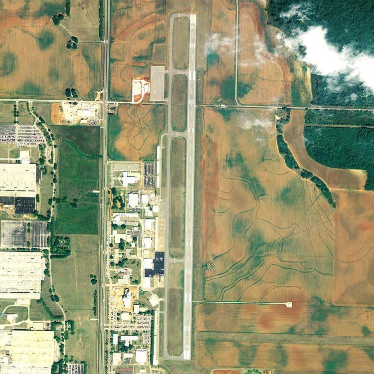
Pryor Field Regional Airport covers an area of 200 acres (81 ha) which contains one asphalt paved runway (18/36) measuring 6,107 x 100 ft (1,861 x 30 m).
For the 12-month period ending May 3, 2006, the airport had 167,701 aircraft operations, an average of 459 per day: 91% general aviation, 7% military and 2% air taxi. There are 144 aircraft based at this airport: 79% single engine, 14% multi-engine, 3% jet aircraft, 3% helicopters and 1% gliders.
The Pryor Field Regional Airport receives $30,000 annually each from the cities of Athens and Decatur and from the county commissions of Morgan and Limestone
History
Opened in October 1941 with 4,600 by 4,600 feet (1,400 m × 1,400 m) square all-direction turf runway. Began training United States Army Air Corps flying cadets under contract to Southern Airways, Inc. & Southern Aviation Training School, Inc. Assigned to Gulf Coast Training Center (later Central FLying Training Command) as a primary (level 1) pilot training airfield.
In addition, the school had had five local auxiliary airfields for emergency and overflow landings:
Flying training was performed with Fairchild PT-19s as the primary trainer. Also had several PT-17 Stearmans and a few P-40 Warhawks assigned.Inactivated on December 28, 1944, with the drawdown of AAFTC's pilot training program. Declared surplus and turned over to the Army Corps of Engineers on September 30, 1945. Eventually discharged to the War Assets Administration (WAA) and became a civil airport.
A newly built $1.8 million terminal building opened in 2008 at the north end of the field as part of a federally funded $3.3 million project. This also included lengthening the runway to 6,000 feet (1,800 m) to accommodate larger jets and improve safety.
In January 2010, the pilot training site was designated a historic landmark and added to the Alabama Register of Landmarks and Heritage.