
 | ||
Similar Freetown‑Fall River State Forest, Dighton Rock, Hockomock Swamp, Anawan Rock, Mound Cemetery | ||
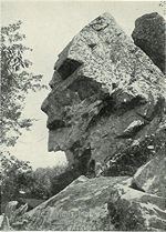
Profile rock park part 1 october 26 2012
Profile Rock, also known as the Old Man of Joshua's Mountain, is a 50-foot high granite rock formation located in Freetown, Massachusetts just outside Assonet village and near the Freetown State Forest.
Contents
- Profile rock park part 1 october 26 2012
- Map of Profile Rock Freetown MA 02702 USA
- Police 3 arrested for tagging profile rock in freetown
- References
Map of Profile Rock, Freetown, MA 02702, USA
Native Americans believe it to be the image of the Wampanoag Chief, Massasoit. The Wampanoags occupied the region of present-day Rhode Island and Massachusetts bounded by Narragansett Bay to the west and the Atlantic Ocean to the east. Chief Massasoit was friendly to the early Pilgrim settlers, and established a period of peace between the two peoples. But after his death, increasing numbers of English colonists and demands for more land caused relations to deteriorate, leading to King Philip's War (named after his son Metacomet or Philip) between the Wampanoags (sometimes referred to as the Pokanoket) and the English, resulting in the tribe’s ruin.
Joshua’s Mountain was named after Joshua Tisdale who was the first to settle near the site. The mountain was privately owned for several years by former Freetown Selectman, Ben Evans, who sold the mountain to the Commonwealth of Massachusetts to be used as a state park tourist attraction. Massachusetts has done little to promote the attraction, however.
In recent years, the site has been frequently vandalized with graffiti, despite an aggressive cleanup effort by the Bristol County Sheriff.