
Population Uninhabited Area 63.76 km² | Highest elevation 265 m (869 ft) Elevation 265 m | |
 | ||
Island group Canadian Arctic Archipelago | ||
Prince Leopold Island is an island in the Qikiqtaaluk Region of Nunavut, Canada. It is located in Lancaster Sound at the junction of Prince Regent Inlet and Barrow Strait. Somerset Island is situated 13 km (8.1 mi) to the southwest; Port Leopold is the closest landmark.
Contents
- Map of Prince Leopold Island Baffin Unorganized NU Canada
- History
- Geography
- Conservation
- Fauna
- References
Map of Prince Leopold Island, Baffin, Unorganized, NU, Canada
History
First named Prince Leopold's Isles by William Parry during his expedition of 1819, after then Prince Leopold of Saxe-Coburg-Saalfeld (the future King Leopold I of Belgium), maternal uncle and adviser of Queen Victoria.
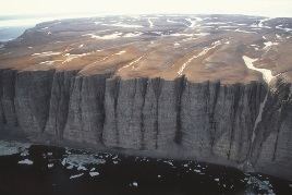
Geography
It is oval-shaped, and 14 km (8.7 mi) east-west by 8 km (5.0 mi) north-south in size.
Conservation
The island is a Canadian Important Bird Area (#NU006), a federally listed migratory bird sanctuary, and a Key Migratory Bird Terrestrial Habitat site (NU Site 15).
Fauna
Large numbers of thick-billed murres, northern fulmars and black-legged kittiwakes breed on the cliff ledges, arriving in the vicinity in May or early June and departing by mid-September. The island is the most important station for breeding marine birds in the Canadian Arctic, having larger numbers and a greater diversity of species than any other site. Intensive studies of the breeding seabirds were carried out in 1975-77 and in a dozen subsequent years, providing evidence of how ice conditions affect the breeding birds.