
References NVE Area 4.12 km² | Surface area 4.12 km (1.59 sq mi) Surface elevation 1,357 m Shore length 20.42 km | |
 | ||
Location Luster (Sogn og Fjordane)and Lom (Oppland) Reference Norwegian Water Resources and Energy Directorate | ||
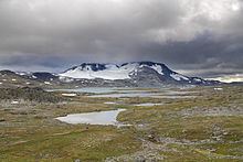
Prestesteinsvatnet is a lake in the municipality of Luster in Sogn og Fjordane county, Norway, with a small part of the lake crossing over into the neighboring municipality of Lom (in Oppland county). The 4.12-square-kilometre (1,020-acre) lake sits at an elevation of 1,357 metres (4,452 ft) above sea level. It lies along the south side of the Sognefjellsvegen road, just to the north of the mountain Fannaråki and the Fannaråkbreen glacier. The lake sits just outside the borders of Jotunheimen National Park. The village of Skjolden lies about 20 kilometres (12 mi) to the southwest of the lake.
Map of Prestesteinsvatnet, Norway
References
Prestesteinsvatnet Wikipedia(Text) CC BY-SA