
 | ||
The history of Preens Eddy, located opposite Coalport and downstream of Jackfield, in Shropshire, England, lies at the heart of the industrial revolution.
Contents
Location and remains of the settlement today
Preens Eddy is a settlement which lies on the south bank of the River Severn between The Woodbridge Inn, just next to Coalport Bridge, and the settlement of The Tuckies on the eastern edge of Jackfield where the Memorial Footbridge crosses the Severn. During the mid 20th Century, a further settlement, The Werps, separated Preens Eddy from The Tuckies and The Werps will be considered as the western boundary Preens Eddy, the River Severn its northern boundary, the Woodbridge Inn its eastern boundary and the track of the old Great Western Railway line, its southern boundary. This means that the most notable landmark of Preens Eddy is the bridge over the Severn linking Broseley with Coalport, originally made of wood and hence called the "Wood Bridge", in contrast to its counterpart made of iron further upstream, famously known as the "Iron Bridge". The origin of name Preens Eddy (or Preen's Eddy) is unclear at the time of writing and contributions are sought to determine whether the Eddy was a swirling current formed by an obstruction in the river or whether Preen was a person, a place or a landmark/feature, or a name possibly linked to the Preenshead woodland location nearby.
Coalport Bridge
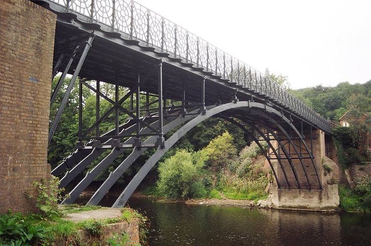
1780–1795 – Architect & Bridgebuilder, William Hayward (1740–1782) designed the first crossing over the Severn at Coalport based on two timber framed arches built on stone abutments and a pier. It was originally built by Robert Palmer, a local timber yard owner based in Madeley Wood, and opened in 1780, the bridge known as Wood Bridge, connected the Parish of Broseley on the south bank of the river, with the Sheep Wash, in the Parish of Madeley and Sutton Maddock on the north bank. Its opening was somewhat played down as the impending showcase "Iron Bridge" further upstream was already being prepared as an icon by Abraham Derby III but the wooden bridge was short-lived and lasted less than 5 years when in 1795, severe winter flooding virtually washed away the mid-stream supporting pier.
1799–1818 – After the destruction of 1795, the bridge remained closed until the Trustees, of what was to become known as Coalport Bridge, had it rebuilt in 1799 as a hybrid of wood, brick and cast-iron parts, cast by John Onions (Proprietor's Minute Book 1791–1827). The two original spans were removed and replaced by a single span of three cast iron ribs, which sprang from the original outer sandstone pier bases. The bridge deck was further supported by two square brick piers, the northern one constructed directly on top of the stone pier base and the southern one set back slightly towards the river bank. The remainder of the superstructure was built of wood and may have reused some of the original beams. However by 1817, this bridge was failing again, attributed to the insufficient number of cast iron ribs proving inadequate for the volume of traffic. Consequently, the bridge proprietors decided to rebuild Coalport Bridge once again, but this time chose to do so completely in iron.
1818–2005 – The date of 1818 displayed on its midspan panel refers to this substantial work which allowed the bridge, subscribed to by Charles Guest, one of the principal trustees, to stand without major repairs, for the next 187 years. John Onions and Guest's brother John, were buried at Birch Meadow Baptist Chapel, Broseley, a chapel for which Guest had earlier paid half of the building costs. Some further strengthening work was carried out on the bridge in 2004-5 when it was closed for about one year to reconstruct the two brick arches supporting the verges at the south side of the bridge. It still takes vehicular traffic, unlike the more famous Iron Bridge, albeit limited to a single line of traffic, a 3-tonne weight limit and a height restriction of 6 ft 6in (1.98 cm).
Toll houses
A detached Grade II Listed former toll house, still sits on the bank of the River Severn, on the High Street, Coalport by Preens Eddy Bridge and was originally built for use as a warehouse between 1793 and 1808, after which it became used as a house by 1815 and as a toll house from 1818. The tolls were collected by the Turnpike Commission trustees, representing the parishes who were responsible for the upkeep of the Coalport Road and locals used to call it the "catchgate" as it "caught you" to pay the toll. The building still has still contains the original spy holes at each side of the property so that the keeper could look out for people trying to use the road without paying a toll. In 1922, the bridge was freed from tolls but it is believed that even after cessation of tolls, the retired toll keeper, a Mr Green and his daughter who lived there, continued to protect the restored bridge by dissuading drivers of heavy vehicles from crossing.
According to local historian, Ron Miles, there was also a stone riverside toll-house for boats entering the Gorge, on the riverside field next to the Severn Valley Way.
Railway station
Preens Eddy once had its own railway station operated by the GWR known as Coalport Station. To avoid confusion in this article it will be referred to as Coalport West Station because on the other side of Coalport Bridge was another Coalport railway station operated by the LNWR, which will be referred to here as Coalport East Station, now demolished. The one at Preens Eddy still exists, now converted to a private residence and sympathetically extended from its original operating days which ceased in 1968. Today, a small portion of the edge of the westbound platform is still visible and the private owners have re-laid a small section of track roughly where the eastbound line would have been and placed upon the track two GWR railway carriages which are rented out as camping coaches.
Bus service
In 1963, a once-a-day bus was pictured at the Coalport Bridge Terminus. It was operated on Route 938 by Midland Red between Wellington and Coalport via Hadley. Coalport East railway station had already closed in 1958 and once Coalport West (Preens Eddy) closed in 1968, the bus & car remained as the only forms of transport for Coalport, having originally been well served by rail, road and river transport.
The Woodbridge Inn
Today, the only remaining public house at Preens Eddy is The Woodbridge Inn, named after the original "Wood Bridge that crossed the Severn here. At postcode location TF8 7JF, its tranquil setting and good car parking attracts many who wish to explore Preens Eddy itself or take an easy walk around The Werps, The Tuckies, Jackfield, GWR Severn Valley Way, The Calcutts, The Hay Inclined Plane and Coalport Basin, China works and Tile Museum & Tar Tunnel museums with 5 or 6 pubs en route.
Historical houses nearby
The only sizeable house of historical note appears to be The Amies, a rectangular, black-and-white building of Tudor styling, which was demolished in the 1890s. All that remains today are some depressions in the field and mentions of it in other articles about the larger Tuckies House located about a mile further west. There were numerous private and commercial relationships between inhabitants of The Amies House and The Tuckies House, both of which had significant impacts on land and business ownership in the Broseley, Coalport and Jackfield areas in general, in the 19th century.