
Location South China Sea | Total islands 3 | |
 | ||
Major islands Pratas Island
North Vereker Bank
South Vereker Bank Area 174 ha (429.96 acres) (land), 64 ha (158.15 acres) (lagoon) Length 2.8 kilometres (1.7 mi) Width 0.865 kilometres (0.537 mi) | ||
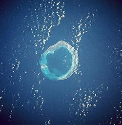
The Pratas Islands, also known as the Dongsha Islands, are an atoll in the north of the South China Sea consisting of three islets about 340 kilometers (211 mi) southeast of Hong Kong. Excluding their associated EEZ and territorial waters, the islets comprise about 240 ha (590 acres), including 64 ha (160 acres) of lagoon area. The People's Republic of China claims the islands, but the Republic of China (ROC) controls them and has declared them a national park. The main island of the group—Pratas Island—is the largest of the South China Sea Islands.
Contents
- Map of Pratas Island Dongsha Islands
- Name
- History
- Geography
- Settlement
- Pratas Island landmark
- Pratas Island stone tablet
- Da Wang temple
- Symbol of national sovereignty
- Measuring memorial stone tablet
- Triangulation bench mark
- Library
- Post office
- Fishermens service station
- Government
- Energy
- Transportation
- References
Map of Pratas Island, Dongsha Islands
Name
The English name of the islands derives from the Portuguese Ilhas das Pratas ("Silver Plate Islands"), which was given to the atoll in the 16th century owing to its round shape.
Dongsha is the pinyin romanization of the Chinese name Dōngshā Qúndǎo (t 東沙群島, s 东沙群岛), meaning "Eastern Sandy Archipelago". The name distinguishes it from Xisha, the western archipelago, better known as the Paracel Islands.
History
The Pratas Islands were first recorded by the Chinese over 1000 years ago in the book "Guangzhou Ji" (廣州記) written by Pei Yuan (裴淵) during the Jin Dynasty. Chinese fishermen fished in the sea around the Pratas by that time.
The East Indiaman Earl Talbot was wrecked on the Pratas Islands on or about 22 October 1800 with the loss of all aboard. At the time the islands were known to British sailors as the "Perates". Then the British screw sloop HMS Reynard was wrecked in 1851 while going to the aid of another wrecked vessel; the crew were all saved.
Between 1859 and 1861 there was a correspondence between the British Colonial Office and the Hong Kong colonial authorities about building a lighthouse on the main island on the atoll. Despite an offer by a British businessman in Xiamen to build it, it was decided that the cost was too great and the matter lapsed. It is clear from the correspondence that no one supposed the atoll to be a part of any known jurisdiction, which might have required negotiations to be conducted to ensure that construction would be legal.
One consequence of this initiative was that in 1858 the Royal Navy survey ship HMS Saracen completed the first detailed survey of the atoll, resulting in the Plan of the Pratas Reef and Island, J. Richards and others, April 1858 being published by the British Admiralty. On the resulting chart three positions are proposed for a lighthouse, on Pratas Island, on the north-east corner and on the southern edge near where HMS Reynard had stranded. In the north-east corner of the lagoon the chart notes "Anchorage for junks" indicating regular use by fishing and other small vessels taking shelter. The chart's rubric noted that the available safe draft for vessels entering was only 15 feet (4.6m), so restricted to only relatively small vessels.
In 1908-1909 a Japanese businessman named Nishizawa Yoshizi (西澤吉次) established a guano collecting station, destroyed the Dawang Joss House (大王庙), and dug up graves and poured the bone ashes of Chinese fishermen into the sea there, and renamed the atoll "Nishizawa Island", but after a diplomatic confrontation, Chinese sovereignty was re-established, and Nishizawa withdrew, after being compensated by the Guangdong provincial government, and after paying compensation for the destruction of a Chinese fishermen's shrine.
Japanese naval personnel occupied Pratas Island during World War II. The Japanese Navy used the island as a weather station and listening outpost until 29 May 1945 when a landing party consisting of Australian commandos and US naval personnel from the submarine USS Bluegill raised the US flag, declared the island a United States territory, and named it Bluegill Island. The landing party destroyed a radio tower, weather station, fuel and ammunition dumps, and several buildings. No lives were lost during this raid as all of the island's occupants fled just days prior to Bluegill's raid. The islands were later restored to the Republic of China's Guangdong Province.
While underway in the South China Sea on 18 July 1965, the USS Frank Knox ran aground on Pratas Reef, and was only freed on 24 August after a very difficult salvage effort.
The islands have been uninhabited, yet nations (including China and Japan) have claimed them to be their overseas territory. After World War II, the islands and the sea around them were mandated by United Nations.
In the Journal of Science (April 1867) there is a nine-page article entitled "The Natural History of Pratas Island in the China Sea" by Dr. Cuthbert Collingwood, the naturalist on board HMS Serpent. It describes what was observed, especially bird life, during a visit of two days while the survey ship lay at anchor. Collingwood explored the island on 30 April 1866.
The islands are currently administered by the Republic of China (Taiwan) with the postal code 817. In 2007, the Taiwan government designated the Pratas as the Dongsha Atoll National Park, the first marine national park in Taiwan.
Geography
The Pratas Islands are located 850 kilometres (530 miles) southwest of Taipei and 340 kilometres (210 miles) southeast of Hong Kong in the northern part of the South China Sea called the Pratas Terrace (20°43′N 116°42′E).
Pratas Island is 2.8 km (1.7 mi) long and 0.865 km (0.537 mi) wide; it is the only feature of the group above sea level. The island is made up of coral atolls and reef flats. Brush, vines and bushes cover some of the island - the rest is white sand.
North and South Vereker Banks are under water.
Other flora and fauna on and around Pratas Island include:
There are also some seamount formations nearby which are not part of the main island:
Settlement
As a disputed island with no permanent inhabitants, it is visited largely by fishermen, military personnel and researchers. Amateur radio operators participating in the DXCC and Islands on the air awards programs also visit occasionally.
Pratas Island landmark
An obelisk erected after 1946.
Pratas Island stone tablet
In 1954 the ROC Government personnel stationed on Pratas erected a stone tablet on the southern side of the island, facing the ocean.
Da Wang temple
The Da Wang temple is dedicated to 'Kuang Kang' and 'The South China Sea Goddess' - Mazu. It is said that the statue of Guan Gong came to Pratas Island on a canoe in 1948. The soldiers on Pratas Island built a temple to worship her in 1975. Today, the canoe is still kept in the temple. The joss sticks and candles are donated by soldiers, as was the golden sign hung in front of the statue. There is an 'Ever Green' pavilion in front of the temple which was also built by the soldiers. It is the most verdant place on the island.
Symbol of national sovereignty
The Minister for Internal Affairs of the ROC erected the South China Sea Defense stone tablet to declare Republic of China sovereignty in 1989.
Measuring memorial stone tablet
In July 1991 the Kaohsiung City Government erected the Pratas Island measuring memorial stone tablet as a symbol that Pratas Island falls within the jurisdiction of Kaohsiung City. Within Kaohsiung, the islands belong to Qijin District.
Triangulation bench mark
The ROC Government established this spot as the triangulation point for Pratas Island in December 1991. There are words on each side of the base of the triangulation point stone tablet. It reads 'The Pratas Triangulation Point' on the front, and 'Longitude: 116o 43" 42.5601'E, Latitude: 20o 42' 6.2415'N, Height: 2.4875 meters.' The words 'Defend the South China Sea', written by the commander, Lo Ben Li, were also engraved on the stone tablet. As the National Tsing Hua University webpage about the island states, "In addition to making it more convenient to survey and draw navigational maps, and to construct and develop facilities on the island, the establishment of the triangulation point is also the basis of our sovereign rights."
Library
The library is located on one side of the main plaza, and is the center for soldiers to obtain spiritual nourishment. The library contains more than two thousand books.
Post office
The ROC area code for Pratas is 817, and the military post office is Office No. 67. The Ministry of Transportation and Communications issued the 'South China Sea Islands Map Stamps' in 1996, as a set of two stamps. The inscription 'South China Sea Defense' from the national stone tablet on Pratas Island was printed on the five-dollar stamp, and the 'Defend the South China Sea' inscription from the national stone tablet on Taiping Island was printed on the seventeen-dollar stamp. The background was the south China coastline, Taiwan and Hainan Island with the blue sky and sea. This was the first time that the ROC had issued stamps with the theme of the South China Sea.
Fishermen's service station
In 1987 the military and civilian occupants built the 'Pratas Fishermen's Service Station'. The station was built in traditional Chinese courtyard house style, and provides convenient services for fishermen and boats in the South China Sea, insuring the fishermen's safety and upholding ROC sovereignty. The services provided include lodging, medical rescue, entertainment and supply. The station also provides lodging for the scientists who come to conduct research on the island.
Government
Although there are no long term inhabitants on the island, Pratas is administered by the Kaohsiung City Government under Cijin District.
Energy
Diesel-fueled generators are used to power up the island. In March 2016, solar energy system built by the Coast Guard Administration went into operation to add to the generation mix of power for the island. The system covers an area of 310.6 m2 and produces 53,200 kWh of electricity each year.
Transportation
The Dongsha Island Airport features a runway located on the north end of Pratas Island with a small airport terminal at the eastern end. The airport is used by the ROC military. A main shack and subordinate shack are located on the southeast end of the island. Two piers on the southeast shore allow for small watercraft to land.