
Country Mexico Time zone CST (UTC-6) Elevation 50 m Population 185,242 (2010) Number of airports 1 | Founded November 20, 1951 Postal code 93261 Local time Saturday 10:40 AM Area code 782 | |
 | ||
Weather 26°C, Wind NW at 11 km/h, 70% Humidity Colleges and Universities Higher Technological Institute of Poza Rica, Universidad Veracruzana | ||
Un paseo dominical en poza rica veracruz
Poza Rica ([ˈposa ˈrika]), formally: Poza Rica de Hidalgo is a city and its surrounding municipality in the Mexican state of Veracruz. Its name means "rich well", because it was a place known for its abundance of oil. In this century oil was discovered in the area. It has since been almost completely extracted. This has resulted in the decline of oil well exploration and drilling activities, though there are still many oil facilities.
Contents
- Un paseo dominical en poza rica veracruz
- Map of Poza Rica de Hidalgo Ver Mexico
- Main Attractions
- Economy
- Neighborhoods
- Parks
- Sights
- Education
- Transport
- Religion
- Urban culture
- Crime
- Tourism
- Food
- Sports
- Geography
- Geology and relief
- Hydrography
- References
Map of Poza Rica de Hidalgo, Ver., Mexico
The city shares borders with the municipalities of Papantla, Tihuatlán, and Coatzintla, and stands on Federal Highway 180. The archaeological zone of El Tajín is located approximately 15 kilometers (9.3 mi) from Poza Rica. The area is intensely tropical, with two popular beaches within one hour, Tuxpan, and Tecolutla, and one within 40 minutes east, Cazones. Mexico City is about 220 kilometers (140 mi) from Poza Rica. Unlike most Mexican cities, it does not have old buildings because it is a new city founded officially on November 20, 1951. For that reason it has contemporary architecture with well-lined and designed streets with a modern look. While the petroleum industry features heavily amongst the industrial landscape in Poza Rica, the city also has a wide variety of other industries with a large middle class. As one of the largest and most populous cities in Veracruz, Poza Rica is an important industrial and commercial center, and a central hub for several road transportation lines. The city has recently seen a lot of growth, with several shopping malls opening around the city. The city had an official population of 174,512 inhabitants and the municipality had 181,438 at the census of 2005. However, the Poza Rica metropolitan area, which includes the municipalities of Papantla, Tihuatlán, and Coatzintla, showed a total population of 458,330.
Main Attractions
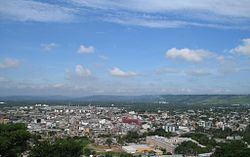
Poza Rica is close to the Costa Esmeralda, the northern beaches of Veracruz, such as Tecolutla, Tuxpan, Cazones and Playa Esmeralda. The UNESCO World Heritage Site of El Tajin is 15 kilometers (9.3 mi) away. It has a downtown area which provides a good shopping experience. It has a local famous height called "El cerro del abuelo" where it's possible to see the whole city and its "quemadores", big petroleum burners which were used to light the city in the early years. There are few of them at the present time. Every year there is a holiday called "Desfile del 18 de marzo" (March 18 Parade, "Petroleum Day") which commemorates Mexican oil expropriation and has two beautiful parades, one in the morning and one in the afternoon. It is a city with a predominantly young population. Though there are few expatriates a few English language schools employ teachers for locals and PEMEX employees.
Economy
Recently the city has experienced a revival in economic activity, driven by investments in oil production by the parastatal PEMEX company. The economy is driven by trade, the petroleum industry, fashion, and tourism. This has brought a boom in trade, which together with its strategic location and concentration of services, causes a daily flow of residents from other towns, municipalities and nearby cities like Papantla, Gutiérrez Zamora, Tecolutla, Martínez de la Torre and Tihuatlán in the state of Veracruz. This extends its area of influence of the neighboring towns and villages State of Puebla that converge to it for various reasons, among which are health, employment, education or shopping, as it is located in the major centers of supply, trade and services.
The city of Poza Rica has three malls: Plaza Gran Patio Poza Rica, which contains the stores Suburbia, Walmart, VIPs, MM cinemas, Cinemex, Burger King, Solo Tennis, Playground, Casino, The Home Depot, Office Depot, Peter Piper Pizza, Church's Chicken, and Pizza Hut, among others; Crystal Square contains Chedraui and Factories in France; Poza Rica Square contains Soria supermarket, MM cinemas, Cinemex, Toy, KFC (Kentucky Fried Chicken), exa fm radio, and Burger King.
Neighborhoods
The city consists of five neighborhoods (The 5 Barrios de Poza Rica).
Parks
The city of Poza Rica has 36 parks. The most important are:
Sights
The city has 18 monuments.
Education
The city has:
5 Nurseries 81 Preschools 110 Elementary schools 46 Public and private high schools 36 Baccalaureate programs 2 Adult Education programs 10 Universities, including 7 private and 3 public
Major universities in the city are the UV Universidad Veracruzana, University Spanish America, the Gulf of Mexico University, the University of the Huasteca, and Technological Poza Rica.
The city has 21 public libraries. The most important are:
Transport
Public transport is the main means of transport of pozarricenses. Transport in the city are buses that take you to different areas of the city, as well as shared taxis.
Poza Rica taxis are the tsuru model that move around the city.
Central Bus Terminal: For land transport with the rest of the country, Poza Rica has three bus terminals:
El Tajín National Airport in Tihuatlán serves Poza Rica.
Religion
Most pozarricenses profess the Catholic faith, but there are groups of Pentecostals, Mormons, Jehovah's Witnesses, evangelical Christians, and Baptists, among others.
Urban culture
In the city are various youth groups like emos, skaters, Punk, Rappers, Cholos, reggaeton, Rastafarians, metalheads, Goths, Darcketos, Popular, Zoot, and Hippies.
Crime
Poza Rica is one of the more dangerous cities in the northern part of the state as it is an area where criminal organizations tend to settle. In 2008 SEDENA PFP and the Navy adopted to monitor the city and chose other strategies to reduce crime in the city.
Tourism
Tourism is a major economic activities of the city as each year thousands of national and international tourists comes into the city, though most are from Mexico City, Guadalajara, Puebla, Pachuca, Monterrey, Tulancingo, Reynosa, Matamoros, McAllen, Dallas, and Houston. The main destinations are the beach which is just 45 kilometers from the city center as well as the archaeological site of El Tajin, where every year a summit is held. Another attraction is the Tajin Teayo Castle.
Food
As for the local cuisine, this is distinguished by typical regional dishes Totonac and Huastec, of which the best known is the Zacahuil, plus a variety of typical Mexican snacks, among which are sopes, bocoles, molotes, tlacoyos, enchiladas, and blanditas.
Sports
Football, baseball, and basketball are sports that are practiced in Poza Rica. The city has a 3rd-rank football team. A professional division called Poza Rica Oil has a team in the 2nd. Another division is called Los Lobos. During the oil splendor the city had a professional baseball team. The Ranger Soccer is considered high quality football. It excels in the football tournament of the Barrios, an event that is organized by the newspaper La Opinión and of which the founder was José Hernández Soto, a character linked to major sporting events in the city. The city has a football stadium located at Heriberto Jara Corona in the northern part of the city, which is home to the Oilers in Poza Rica.
Geography
The administrative boundaries of the municipality are determined by the municipality northeast of Papantla, south to the town of Coatzintla and to the northwest by the municipality of Tihuatlán, separated from the latter by the course of the river Cazones.
Geology and relief
The center of the city sits in a small valley on the basin river Cazones, in the coastal plain of the Gulf of Mexico, with an average altitude of 60 m, although most of the land sits on uneven ground and mostly hills northeast of the city, among which is the Cerro del Meson, with a maximum height of 242 meters. The predominant soils are of the vertisol type, with a high content of clay forming expansive cracks in dry seasons.
Since its inception, the rapid urban growth in extension exceeded the capacity of available flat land in the city, expanding the urban area to the northeast of the city, using increasingly uneven ground and hills bordering the town of Papantla, inhabiting the slopes of the hills that surround the city center.
Hydrography
The town of Poza Rica is located in the watershed of the river Cazones, this River 100 km long born in the mountainous region of Hidalgo and flows into the Gulf of Mexico, has a higher average annual runoff of 40 m³ / s in its mouth. The city is also surrounded by several Cazones River tributary streams such as the Mollejón, Hueleque, Salsipuedes and Arroyo Corn, which is regularly affected by flooding the annual rainy season.
Mexico's only nuclear power plant (Laguna Verde) is about 200 kilometers (120 mi) away, near the state's capital city of Xalapa, Veracruz.