
OS grid reference TQ264120 Sovereign state United Kingdom Local time Saturday 4:29 PM Dialling code 01273 | Civil parish Poynings Area 6.66 km² | |
 | ||
Population 287 2001 Census432 (2011 Census) Weather 12°C, Wind NE at 27 km/h, 31% Humidity | ||
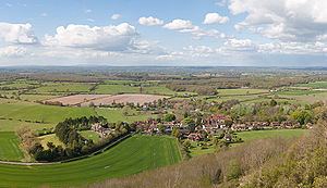
Poynings (/ˈpɔːəniŋs/ or /ˈpʌniŋs/) is a village and civil parish in the Mid Sussex District of West Sussex, England. The village is located on the north side of the South Downs near Devil's Dyke, five miles (8 km) north-west of Brighton. The civil parish covers an area of 665.5 hectares (1,644 acres) and has a population of 287 (2001 census), including Newtimber and increasing to 432 at the 2011 Census.
Contents
Map of Poynings, Brighton, UK
There is an Anglican parish church dedicated the Holy Trinity and a public house, the Royal Oak. In the village opposite Holy Trinity Church there is a small sheltered memorial called Cora's Corner, which pays tribute to a former resident of Poynings; two benches in the shelter, Judy's Seat and Merrilee's Seat, are tributes to Cora's two daughters. The road linking Cora's Corner to the Royal Oak is called Cora's Walk.