
Topo map USGS Potosi Prominence 918 m | Elevation 2,596 m | |
 | ||
Similar Mummy Mountain, Hayford Peak, McFarland Peak, Griffith Peak, Mount Wilson | ||
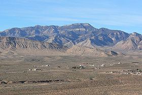
Potosi Mountain, located in Clark County, Nevada, is one of the six high points surrounding Las Vegas. Potosi Mountain is about 30 miles (50 km) southwest of Las Vegas in the Spring Mountains, in Clark County of southern Nevada.
Contents
Map of Potosi Mountain, Nevada 89161, USA
Potosi Mountain was the site of the TWA Flight 3 air crash that killed 22 passengers, most notably the actress Carole Lombard, on January 16, 1942.
The Geographic Names Information System lists two variant names for the location: Double Up Mountain and Olcott Peak.
Potosi Mountain broadcasting facility
Potosi Mountain serves as a major FM broadcast transmitter site for Las Vegas, with 7 full power FM stations transmitting from the top of Potosi, along with 1 FM Translator. The stations are KNPR 88.9, KCNV 89.7, KOMP 92.3, KYMT 93.1, and KXPT 97.1 all licensed to Las Vegas, KFRH 104.3 licensed to North Las Vegas, and KXTE 107.5, licensed to Pahrump, Nevada. A translator, K276BL, also operates from up here on 103.1, simulcasting KSOS 90.5 from Las Vegas. KXTE was the first tenant to broadcast from the top of the mountain and the first station in the United States to transmit in HD Digital.
There is also an amateur television repeater, with the call sign N7ZEV, located here.
Along with FM transmitters, NOAA All Hazards Radio station WNG634 on 162.400 MHz, which is managed by the NWS Office in Las Vegas, NV is located here as well.