
Country Ireland Time zone WET (UTC+0) Local time Friday 5:03 PM | Irish Grid Reference C055307 | |
 | ||
Weather 11°C, Wind E at 10 km/h, 62% Humidity | ||
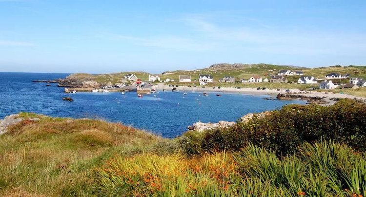
Portnablagh county donegal
Portnablagh (Irish: Port na Bláiche, meaning, depending on translation, either 'port of the flowers' or 'harbour of the buttermilk', possibly from the rough seas in the area) is a small village in County Donegal, Ireland. Portnablagh (also written in English as Port-na-Blagh) is located on Donegal's North West coast, specifically the west side of Sheephaven Bay. It is on the N56 road.
Contents
- Portnablagh county donegal
- Map of Portnablagh Co Donegal Ireland
- Donegal portnablagh dunfanaghy sessiagh lake
- Faugher House
- References
Map of Portnablagh, Co. Donegal, Ireland
Portnablagh, along with neighbouring Dunfanaghy, is well known for its beaches and picturesque harbour. It attracts many tourists, mostly from Northern Ireland, every summer.
The small harbour is well protected on 3 sides and has a relatively short slipway which gets frequent use by fishing and pleasure boat owners, particularly during summer months. It provides access for boat owners to a large number of beaches in Sheephaven Bay, many of which are only accessible on foot or by sea.
Donegal portnablagh dunfanaghy sessiagh lake
Faugher House
On the south-eastern edge of Portnablagh, between Ards Forest Park and Portnablagh itself, lie the ruins of Faugher House, also known as O'Boyle's Castle or Wray's Castle. This small fortified house and its surrounding bawn were built during the Plantation of Ulster, and may have been built in stages throughout the seventeenth-century. The original 'castle' or fortified house on this site was probably built for Turlough Roe O'Boyle about 1611. The surviving bawn on the site probably dates from this time, very early in the Plantation of Ulster.
However, the surviving 'Plantation-era' fortified house (now ruined) may have been built in the second half of the seventeenth-century, possibly for the Wray family. The building was probably abandoned by the mid-eighteenth-century. The rather 'Scottish-style' ruin is beside 'the Middle Road', a sideroad leading to Breaghy Head, just off the N56, the main Letterkenny to Dunfanaghy road. The site is privately owned and is not open to the public.