
Country United States Size of harbor 500 acres (200 ha) | Type of harbor Natural/Artificial | |
 | ||
Location Boston, Suffolk County, MA Operated by Massachusetts Port Authority
(Massport) Owned by Government of Massachusetts Owner Government of Massachusetts | ||
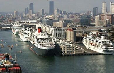
Port of boston usa
The Port of Boston, (AMS Seaport Code: 0401, UN/LOCODE: US BOS), is a major seaport located in Boston Harbor and adjacent to the City of Boston. It is the largest port in Massachusetts as well as being one of the principal ports on the east coast of the United States.
Contents
- Port of boston usa
- AdministrationEdit
- HistoryEdit
- Ground transportationEdit
- Massport facilitiesEdit
- Non Massport facilitiesEdit
- Piers and wharvesEdit
- Foreign Trade ZoneEdit
- Traffic and statisticsEdit
- Port policeEdit
- References
The Port of Boston was historically important for the growth of the City of Boston, and was originally located in what is now the downtown area of the city, called Long Wharf. Land reclamation and conversion to other uses means that the downtown area no longer handles commercial traffic, although there is still considerable ferry and leisure usage at Long Wharf. Today the principal cargo handling facilities are located in the Boston neighborhoods of Charlestown, East Boston, and South Boston, and in the neighboring city of Everett. The Port of Boston has also been an entry point for many immigrants.
AdministrationEdit
The Massachusetts Port Authority (Massport) was created in 1956 by a special act of the Massachusetts General Court. The Massachusetts Secretary of Transportation and Public Works serves as an ex-officio member of the board and the remaining six members are appointed by the governor to staggered seven year terms. Its Board members must be residents of Massachusetts. The Department of Homeland Security also has a presence with United States Customs Service and United States Border Patrol agents. The port has three areas of activity: cargo, cruises and ferry service.
HistoryEdit
Before the colonization of the Americas, the area served as a trading post for Native Americans in the region. After the establishment of the Boston settlement by John Winthrop in 1630 and the creation of a local shipbuilding industry, the port served the rapidly expanding American colonies. During that time, trade involved finished goods from England in exchange for lumber, fully constructed vessels, rum, and salted fish.
With the rapid growth of the Mid-Atlantic colonies in the 1750s, the ports of New York and Philadelphia, Pennsylvania began to surpass Boston for inter-colony trade. In response, Bostonian merchants established trade with foreign nations besides Great Britain. This trade led to a huge increase in wealth amongst local Bay State merchants. However, the British government's imposition of regulations restricting trade to Great Britain, combined with newly enacted taxes on the colonists, caused Bostonian merchants to join the more radical elements in American society. After the Boston Tea Party, the British Parliament passed the Boston Port Act which shut down the port until the East India Company was compensated for the damaged tea These actions led to the American Revolutionary War.
Though economically devastated by the Revolutionary War, the Port of Boston was again prospering with trade with various foreign ports such as Shanghai. The port's fortunes were further augmented with a navy base at Charlestown. By the mid-19th century, the shipbuilding industry reached its peak as displayed by the clipper ships developed by Donald McKay. The port also saw many land reclamation projects and the construction of new piers.
With the start of the Industrial Revolution in the United States, activity in the port turned towards trade between the states. Starting in the mid-19th century, the Port of Boston was eclipsed yet again by other eastern seaboard ports such Port of New New York City as local merchant companies were bought out by New York businessmen. In 1956, control of the port was handed to the Massachusetts Port Authority (Massport), which began the process of modernizing the port. During the 1980s and 1990s, a project dedicated to the cleanup of Boston Harbor was overseen by the Massachusetts Water Resource Authority (MWRA).
In 1966, Sea-Land introduced containerized shipping and later established one of the first container ports on Castle Island, where Conley Terminal now stands. To meet the growing demand for container shipping, Massport constructed a common-use container port on what is now Moran Terminal. However, the port faced a setback with the closure of the Charlestown Navy Yard in 1974.
In the mid-1990s, the port went through another round of modernization. Container shipping operations were consolidated at Conley Terminal while Moran Terminal was dedicated to automobile shipping. A project of dredging the harbor commenced in 1997. Through the Central Artery/Tunnel Project (Big Dig), ground access to the South Boston facilities were improved with the extension of I-90 and the construction of the Ted Williams Tunnel linking South Boston with East Boston and Logan International Airport. The port has also seen a burgeoning cruise industry as well as expanding commercial and residential developments on the Boston waterfront.
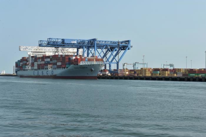
With the Panama Canal expansion project expected to accommodate larger ships starting in 2016, the United States Army Corps of Engineers plans to dredge harbor access routes starting in 2017, deepening them from 40 to 47 to 51 feet. This will allow visits by container ships carrying up to 10,000 TEUs, up from 7000 TEUs, and reduce the amount of freight which is expected to be shipped to the Port of New York and New Jersey and trucked to Massachusetts. The project is estimated to cost $310 million and is paid for by the federal Water Resources Reform and Development Act (about two-thirds), Massport, and an additional allocation from the Commonwealth of Massachusetts.
Ground transportationEdit
The Port of Boston has access to I-90, I-93, I-95, and U.S. 1, including a truck-only haul road. Track 61 runs through the port, but As of 2015 is not in active use. There is public transit access via the MBTA Silver line SL2 route.
Massport facilitiesEdit
The public facilities, operated by the Massport, are located in the neighborhoods of Charlestown, East Boston, and South Boston. These include:
Non-Massport facilitiesEdit
The Port of Boston has facilities dedicated to bulk cargo, petroleum, and LNG shipment and storage. These are primarily located on the Mystic River, notably along the city of Everett waterfront as well as the Chelsea River area of East Boston, Chelsea, and Revere. The Chelsea River depots also contain facilities handling jet fuel for Logan International Airport. The Deer Island Waste Water Treatment Plant, whose 150-foot-tall (46 m) egg-shaped sludge digesters are major landmarks, ships treated sludge across the harbor by barge for further processing into fertilizer.
The US Coast Guard has a base in Boston, and the naval frigate USS Constitution ("Old Ironsides") is berthed at the former Charlestown Navy Yard, now part of the Boston National Historical Park. The park is also home to the USS Cassin Young a World War II museum ship. The park's Drydock Number 1 was completed in 1833 and first used by the Constitution. It is now used to overhaul historic ships, including Constitution in 1992 and Cassin Young in 2007. Two other pre-World War II-era dry docks in the harbor are still operational (as of 2014), including Dry Dock Number 3 — one of the largest dry docks on the U.S. East Coast — which regularly repairs ships for the Military Sealift Command. These are located at the former South Boston Naval Annex.
MBTA Boat, water taxis, and private ferries and small cruise boats also use docks at Rowes Wharf, Long Wharf, Boston Navy Yard, Logan International Airport, Hewitt's Cove in Hingham, Pemberton Point in Hull, and the Fore River Shipyard in Quincy, and a number of small docks at destinations around the harbor. The Boston Harborwalk provides public access to much of the harbor's edge.
Piers and wharvesEdit
Boston's port was historically served by many more wharves and pier facilities. Although Massport maintain the more notable ones, a handful of docking facilities in the Boston Harbor are maintained by private interests or other state agencies such as DCR. Further, some wharves have been converted to residential condominiums, or hotel accommodations.
The Port's current and former wharves include:
Foreign Trade ZoneEdit
Massport manages Foreign Trade Zone (FTZ) No. 27, which includes many privately owned and port-owned sites located throughout Suffolk County, Massachusetts.
The following Sub Zones are a part of The Port of Boston FTZ No. 27:
Traffic and statisticsEdit
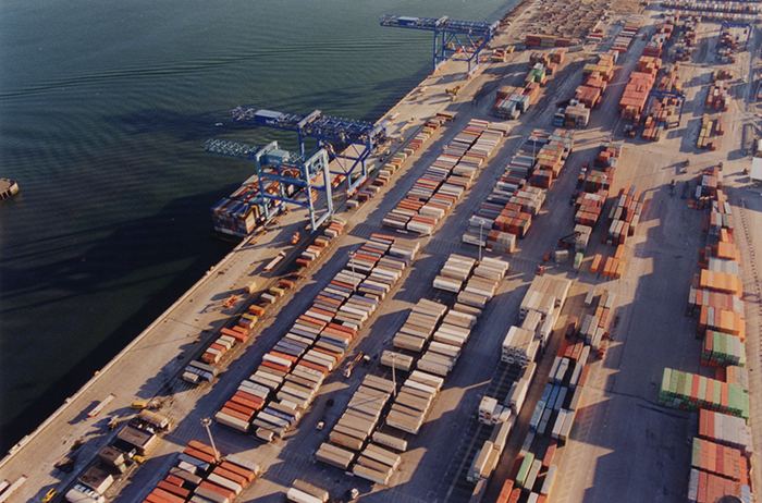
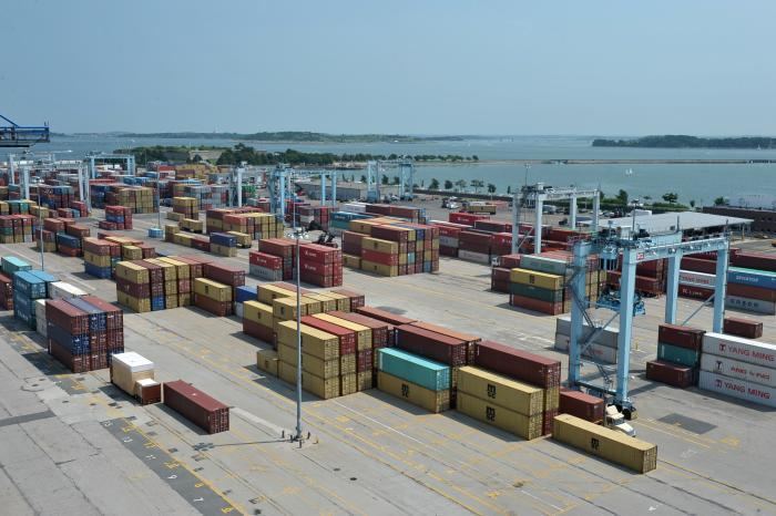
In 2015, the port handled 237,000 container TEUs, 60,000 automobiles, and 121,000 metric tons of cement. Other major forms of cargo processed at the port include petroleum, liquefied natural gas (LNG), gypsum, and salt. There were 328,305 cruise ship passengers that year. Some 114 vessel calls are scheduled for the 2016 cruise season.
In the wake of the September 11, 2001 attacks, there have been concerns about the security of LNG shipments within Boston Harbor, and increased fear of terrorism. Because of the location of the LNG terminal in the Mystic River, tankers traveling to and from the facility are forced to pass directly offshore of downtown Boston. During their voyage through the harbor, they are protected by a security zone that extends 2 miles (3.2 km) in front of the vessel, 1-mile (1.6 km) behind it, and more than half a mile on either side. This zone is enforced by escort vessels provided by the Coast Guard and State Police. The Tobin Bridge is closed as the escort passes under it, and boating is forbidden within the security zone. As of 2005, there have been proposals to construct an offshore LNG facility on either Outer Brewster Island in the Harbor, or further a field in the wider Massachusetts Bay.
The MBTA operates commuter boats between Long Wharf and Rowes Wharf on the downtown Boston waterfront to Hingham, Hull, Quincy, and Logan Airport as well as inner harbor ferries between downtown Boston, Charlestown, and South Boston. Other fast passenger ferries operate to Provincetown and Salem. Several companies operate cruise boats on the harbor, whilst water taxis operate from various points on the downtown Boston waterfront, Logan Airport, Charlestown, East Boston, and South Boston. Ferries are also provided for travel amongst the harbor islands.
There are occasionally marine accidents, as with a commuter ferry Massachusetts going from Boston's Rowes Wharf to Hull in June 2006.
Port policeEdit
The Massachusetts Port Authority (MassPort), which itself was constituted in 1956 maintained its own police force of fully certified and sworn law enforcement officers of the Commonwealth of Massachusetts. This has since been transferred to the Massachusetts State Police—Troop F which currently provides cooperation with Massport. The state police officers are responsible for physical security and law enforcement at the marine terminals and various properties owned by the authority. This has caused a number of jurisdiction squabbles betweens the State and Boston Police Department.