
Opened 1965 | Location Akita Type of harbor Seaport Annual cargo tonnage 7,319,586t | |
 | ||
Similar Tsuchizaki Station, Oga Peninsula, Akita Station, Kubota Castle, Senshu Park | ||
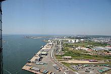
The Port of Akita (秋田港, Akita-kō) is a seaport on the Sea of Japan coast of Akita Prefecture, to the west of the city center of Akita in the Tōhoku region of northern Honshū, Japan. It is classified as a Major Port (重要港湾, Jūyō-kōwan) by the Japanese government. The port has a total land area of 662.5 hectares.
Contents
Map of Japan, %E3%82%A2%E3%82%AD%E3%82%BF%E3%82%B3%E3%82%A6
History
During the Edo period, Akita was an important port of call on the Kitamaebune route of coastal trade from Osaka to Hokkaido and an important source of revenue for the Satake clan’s Kubota Domain. In modern times, during the Meiji period a breakwater was completed in 1885 and enlarged in 1902, and Tsuchizakiko Port was designated a “secondary port” by the Japanese government in 1910. When the town of Tsuchizaki was annexed by the city of Akita in 1941, the port was officially renamed “Akita Port”. The port facilities were extensively damaged in American air raids on August 14, 1945.
After World War II, the port was improved, with the breakwater extended partly though the sinking of the hulks of the kaibokan Ikara and destroyers Momo and Take. Akita Port received the designation of “major port” from the Japanese government on January 19, 1951 and “special port” designation in 1962. A customs office was opened in 1964, permitting international trade. The Akita Northern Port extension was opened in 1970.