
Traversed by D25 Elevation 2,001 m | ||
 | ||
Similar Ax 3 Domaines, Plateau de Beille, Col de Menté, Col de Peyresourde, Col de Marie‑Blanque | ||
Tour de france 2007 port de pailh res
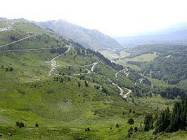
The Port de Pailhères (or Col de Pailhères) (elevation 2,001 m (6,565 ft)) is a mountain pass in the Ariège department of the French Pyrenees, located on the secondary road D25 between Mijanès (south-east) and Ax-les-Thermes (west).
Contents
- Tour de france 2007 port de pailh res
- Map of Port de PailhC3A8res 09110 Ascou France
- Details of climb
- Tour de France
- References
Map of Port de Pailh%C3%A8res, 09110 Ascou, France
Details of climb
Starting from Mijanes, the Col de Pailhères is 10.6 km (6.6 mi) long. Over this distance, the climb is 871 m (2,858 ft) (an average gradient of 8.2%) with a maximum gradient of 10.2%.
Starting from Ax-les-Thermes, the Col de Pailhères is 18.6 km (11.6 mi) long. Over this distance, the climb is 1,281 m (4,203 ft), (an average gradient of 6.9%) with a maximum gradient of 10.4% near the summit.
Tour de France
The climb has been used in five stages of the Tour de France cycle race with its first appearance coming in 2003. In 2013, it was used on the eighth stage, when the riders also competed for the Souvenir Henri Desgrange.