
District O.R.Tambo Established 1845 Local time Friday 12:50 PM | Municipality Port St Johns Postal code (street) 5120 | |
 | ||
Weather 21°C, Wind SW at 27 km/h, 86% Humidity | ||
Port St. Johns (or Port Saint Johns) is a town of about 6,500 people on the Wild Coast in the Eastern Cape province of South Africa. It is situated at the mouth of the Umzimvubu River, 220 kilometres (140 mi) northeast of East London and 70 kilometres (40 mi) east of Mthatha.
Contents
- Map of Port St Johns 5120 South Africa
- Geography climate and geology
- History
- Tourism and road access
- References
Map of Port St Johns, 5120, South Africa
Geography, climate and geology
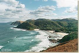
Port St. Johns is situated on the Wild Coast, a coastline of about 270 km long, boasting some of the most beautiful natural scenery in the country. It lies at the mouth of the Mzimvubu River, a river flowing through an impressive gorge known as the "Gates of St John" into an estuary located on the Indian Ocean. On both sides of the river ravine are high sandstone mountain peaks: Mount Thesiger (342 meter above sea level) and Mount Sullivan (304 meter), named after two British Military officers.
It is the main settlement in the Port St. Johns Local Municipality which forms part of the O.R. Tambo District Municipality in Pondoland of the former Transkei. According to the 2011 census it had a population of 6,441, of whom 90% where Xhosa-speaking.
The climate is humid subtropical (Köppen: Cfa).
In the area near the town, some of the most significant Travertine deposits in South Africa are found. About 10 km west of Port St. Johns, sandstone is excavated for architectural use.
History
This town is thought to have been named after a Portuguese ship (the São João), which was actually wrecked at Port Edward. Later seafarers mistakenly identified the mouth of the Umzimvubu River as the site of this wreck.
In the mid 1800s the local Mpondo Chief, Ndamase, allowed a few white traders to settle at the mouth of the Umzimvubu River. When Chief Ndamase died in 1876, the Mpondo Great House in Lusikisiki tried to take over the area. On 17 July 1878, Chief Ndamase's oldest son Nqwiliso, reacted by ceding the western bank of the Umzimvubu River to the Cape Colony in return for being recognised as an independent ruler and he and his people were promised protection. The river mouth was used as a port, however this activity was abandoned in the 1940s due to siltation, which caused the river to become too shallow for vessels.
The town was the principal port of the defunct Republic of Transkei (1976-1994).
Tourism and road access
Port St. Johns is known as the centre of tourism on the Wild Coast. It is famous for deep sea fishing and shore angling. Near to the town are three beaches.
From Mthatha in the West and Flagstaff in the North the R61 road connects to Port St. Johns. A smaller road leads the last 5 km into town. Port St. Johns has an airstrip on top of Mount Thesiger.
The Pondoland Park is a National park and forested area 500 km² in size, including the Umzimvubu river mouth and stretching north along the coast up to the provincial border with KwaZulu-Natal.