
Basin countries Australia | Surface elevation 0 m (0 ft) | |
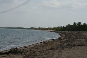 | ||
Port Musgrave is a shallow, almost enclosed, estuarine bay located on the western coast of the Cape York Peninsula in Far North Queensland, Australia.
Two major rivers, the Wenlock and the Ducie discharge into it. The bay itself and the area surrounding it is defined as the Port Musgrave Aggregation DIWA nationally important wetland. The surrounding area is rich in freshwater swamps, while the estuary itself has tidal flats and mangroves, including stands of the Nipa Palm. It is an important breeding area for saltwater crocodiles. The small Aboriginal community of Mapoon lies on the southern shore of the bay.
The bay was discovered by Europeans in 1887 by Hugh Milinan and Edward Cullen who named the bay in honour of Sir Anthony Musgrave, at the time, the Governor of Queensland.