
OS grid reference SX003808 Post town PORT ISAAC Local time Friday 9:19 AM | Sovereign state United Kingdom Postcode district PL29 Dialling code 01208 | |
 | ||
Weather 8°C, Wind NE at 27 km/h, 86% Humidity | ||
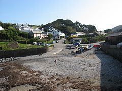
Port Gaverne (Cornish: Porthkaveran) is a hamlet on the north coast of Cornwall, England, UK, about half a mile east of Port Isaac.
Contents
Map of Port Gaverne, Port Isaac, UK
Although it is recognised as an independent hamlet by the Cornish, many tourists consider it as part of the larger village of Port Isaac, partially due to the reason it is home to only four businesses: two hotels, a campsite and a small seasonal beach shop.
Diving port gaverne cornwall england
History
Until the nineteenth century, Port Gaverne was a small port similar to many others on the north coast of Cornwall. Its principal trade was the export of slate from the large quarry at Delabole, five miles to the northeast. Coal was imported and other local produce was exported. When the North Cornwall Railway (absorbed by the London & South Western Railway) line to Wadebridge opened in the 1890s, transport of Delabole slate switched to rail and Port Gaverne lost most of its trade.
The beach is maintained by the National Trust and Port Gaverne Beach Association.