
Population 1,215 (2006 census) Postcode(s) 6525 Postal code 6525 | Established 1867 Elevation 10 m Local time Friday 5:04 PM | |
 | ||
Weather 24°C, Wind S at 37 km/h, 56% Humidity | ||
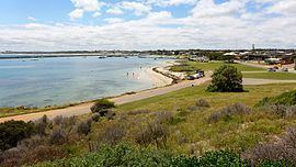
Port Denison is a crayfishing town of 3000 residents in the Mid West region of Western Australia. Its local government area is the Shire of Irwin and it is located 4 kilometres (2.5 mi) southwest of Dongara on the Indian Ocean coast.
Contents
Map of Port Denison WA 6525, Australia
History
Port Denison was initially known as Irwin Port in 1866 due to its position near the mouth of the Irwin River. However, when it was officially named and gazetted in 1867, it was renamed in honour of Sir William Denison, a former Governor of Tasmania who in 1851 had visited Western Australia in connection with transportation of convicts.
References
Port Denison, Western Australia Wikipedia(Text) CC BY-SA