
Country Australia Basin area 6,071 km² | Length 140 km Source elevation 326 m | |
 | ||
Main source Near Pindar326 metres (1,070 ft) River mouth Arurine Bay, between Port Denison and DongaraSea level Basin size 6,071 square kilometres (2,344 sq mi) | ||
Commercial constructions geraldton irwin river steel pty ltd
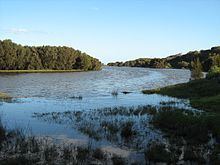
The Irwin River is a river in the Mid West of Western Australia. It was named on 9 April 1839 by the explorer George Grey, while on his second disastrous exploration expedition along the Western Australian coast, after his friend Major Frederick Irwin, the Commandant of the Swan River settlement, and later acting Governor of Western Australia from 1847 to 1848.
The headwaters of the Irwin are located below Canna near Pindar. The river flows west until discharging into Arurine Bay near Dongara.
The river has four tributaries: Lockier River, Sand Plain Creek, Nangetty Creek and Mullewa Creek.
The river occasionally floods as it did in 1945 following a severe storm that swept over the area. The river broke its banks and caused extensive damage including the loss of 450 sheep that were swept away from a farm that straddled the river.