
Country Greece Postal code 180 20 Website www.poros.gr Regional unit Islands | Time zone EET (UTC+2) Vehicle registration YI, YK, YM, YN Area 49.58 km² Area code 22980 | |
 | ||
Points of interest Archaeological Museum of Poros, Zoodochos Pigi Monastery, Vagionia bay, Poseidon temple | ||
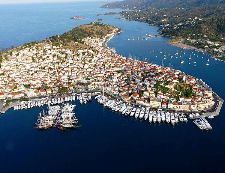
Poros (Greek: Πόρος) is a small Greek island-pair in the southern part of the Saronic Gulf, about 58 km (36 mi) (31 nautical miles) south from Piraeus and separated from the Peloponnese by a 200 m (656 ft) wide sea channel, with the town of Galatas on the mainland across the strait. Its surface area is about 31 square kilometres (12 sq mi) and it has 3,780 inhabitants. The ancient name of Poros was Pogon. Like other ports in the Saronic, it is a popular weekend destination for Athenian travellers.
Contents
- Map of Poros 180 20 Greece
- Transportation
- Geography
- Geology
- History
- Antiquity
- Roman and Byzantine times
- Venetian occupation
- The Ottoman Period
- The Greek Revolution
- Russian Naval Base
- Twentieth century
- Main sights
- Notable people
- References
Map of Poros, 180 20, Greece
Poros consists of two islands: Sphairia (Greek: Σφαιρία, pronounced [sfeˈria]), the southern part, which is of volcanic origin, where today's city is located, and Kalaureia (Greek: Καλαυρία, [kalavˈria]), also Kalavria or Calauria (meaning 'gentle breeze'), the northern and largest part. A bridge connects the two islands over a narrow strait.
Poros is an island with rich vegetation. Much of the northern and far eastern/western sides of the island are bushy, whereas large areas of old pine forest are found in the south and center of the island. It has a good road network and adequate tourist infrastructure, which makes it a popular resort for short holidays.
Transportation
Though possessing no airport, Poros is easily accessible from Athens via ferry or hydrofoil. One can reach the island by car or bus from the adjacent mainland at Galatas.
There is local bus service on the island from Poros harbor to the nearby towns of Neorio and Monastiri.
Geography
The land area of the municipality (which includes the islands and part of the adjacent Peloponnese coast) is 49.582 square kilometres (19.144 sq mi). The landscape is very hilly and mountainous. The highest peak is the Vigla (358 m) in the west-central part. Following the island's topography and geology, small creeks and seasonal streams flow through steep valleys of the southern and northeastern part. The western and northern part of the island feature smooth hills and shallow valleys. Sandy beaches are restricted to the southern shore of the island, except for a bay in the northern part called Vayionia.
Poros contains the following villages:
Geology
The geology of the island comprises Mesozoic to Cenozoic sedimentary rocks (limestone, and Flysch-type sandstone) and ophiolites, as well as Neogene volcanic rocks on Sferia. The island is tectonically dissected and part of a Tertiary tectonic mélange. There are karstic sinkholes in the island's central limestone massif, and limestone caves with stalactites. Visible marine fossils are mainly found in the limestone, no occurrences of precious stones or ore deposits are known.
History
In the northeastern part of the island, in a location called “Kavos Vasili”, the archaeologists have discovered the ruins of a settlement of the Early Bronze Period. This settlement is the oldest of the wider area of Trizinia, Peloponnese, and is believed to be interrelated with the wreck found on the nearby Dokos island which dates to the same period.
Antiquity
The ancient polis of Kalaureia was home to an asylum dedicated to Poseidon, the ruins of which are still accessible on a hilltop close to the town. This asylum may have been linked to the sanctuaries at Geraistos and Tainaros. Ancient historians claimed that Poros was home to an Amphictyony in the Archaic period, a league of the poleis Poros, Athens, Prassiai, Aegina, Epidaurus, Hermione, Troizen, Nauplion and Orchomenus. However, there is no evidence for this, and modern scholars believe the Amphictyony may have been a Hellenistic invention. An enormous feast was found dating to the Hellenistic period in the ruins of the Kalaureia asylum, along with a plaque celebrating the "revival" of the Kalaureian League.
Poros was divided in two islands during the antiquity: the one was called Sfairia and is the part of the island where today is located the island’s capital; the other was called Kalavria and is the bigger part of Poros at the north of Poros Town. During the Mycenaean dominance (1400-1100 BC) Kalavria was quite powerful as the most important naval base of the wider region was located on islet Monti or Liontari in the eastern coast of Poros. In the 7th century BC, it is believed that Kalavria was part of an “amphictyonia”; that is an alliance between multiple City-states. The amphictyonia was named “Amphictionia of Kalavria” and its members were Athens, Poros, Aegina, Epidaurus, Hermione, Trizina, Nafplio, Orchomenos and Prasies. During the 5th century, the Persians started attacking the Greek territories along with the Aegean islands. With the beginning of the Peloponnesian War, which also affected the islands of the Argosaronic Gulf, Trizina and Kalavria offered asylum to the anti-Macedonian politician who eventually became the tyrant of the region. After the death of Alexander the Great in 323 BC, the Ptolemies of Egypt occupied Kalavria. Around that time, the famous orator Demosthenes came to the island and some say that this is the place where he committed suicide. In 273 BC, the last explosion of the Methana volcano dramatically changed the morphology of Poros and the wider region. The Sanctuary of Poseidon has been excavated by Swedish archaeologists, one field season in 1894 considered to be the first Swedish archaeological campaign in Greece, and continued excavations from 1997 and onwards in collaboration with the Greek National Heritage Board.
Roman and Byzantine times
During the Roman period (86 BC to 395 AD) Poros was part of the Roman Empire along with Trizina, to which it was a tributary. In Byzantine times, Poros and other islands were often raided by the pirates that dominated the Aegean Sea.
Venetian occupation
In 1484 the Venetians occupied Poros and used it as a strategic port in their sea battles with the Ottomans. Poros was the most powerful city of the wider area, also governing Methana Island, Epidaurus, Damalas (Trizina), Fanari and Valario. During that time, the island had about 15,000 inhabitants, making it one of the largest cities in Greece. Venetian rule ended in 1715.
The Ottoman Period
The Ottoman Period began in 1715, much later in Poros than in the rest of Greece. Shipping and commerce were the inhabitants’ main activities, but Poros’ fleet wasn’t as famous as Hydra’s or Spetses’ fleet, due to the fact that it did not participate in many sea battles.
The Greek Revolution
Poros had an important role during the Greek Revolution in 1821, due to its strategic position. The Greek revolutionary leaders, often met in Poros to discuss and plan their future actions. The first Greek naval base was established in Poros in 1828 and remained there until 1878. In September 1828, the ambassadors of England, France and Russia met in Poros with Ioannis Kapodistrias in order to determine the borders of the future Greek state, which was established two years later, in 1830.
Russian Naval Base
With the Treaty of Kuchuk Kainarji, Russia secured free shipping for its navy, war and merchant alike, throughout the waters of the Ottoman Empire. As Russian naval activity grew, need arose for a supply station, and land was acquired at the edge of Poros town. Extensive materiel, coal, and food storage facilities were built, as well as a hardtack baking factory. After Greek independence, Governor Capodistrias requisitioned the facilities for use of the Greek war navy, and offered the Russians an alternative location in a nearby cove. The new facilities were far larger, and were used by Russian ships throughout the 19th century. The number of Russian residents of Poros increased and even a Russian school was established. Then as Russian naval activity declined, so did the base and by the early 20th century only a single Russian watchman was left guarding it. It was then granted to the Greek Navy by the Czar but was never put to actual use, and the abandoned buildings were left to decay. The ruins, in elaborately carved stone, were listed as protected architectural monuments in 1989.
Twentieth century
In the beginning of the 20th century, among the activities of the Poros’ inhabitants were agriculture (mainly wheat, grapevines and olives), livestock, fishing and shipping.