
Country France Canton Pontivy Area 24.85 km² | Arrondissement Pontivy Intercommunality Pontivy Communauté Local time Thursday 11:41 PM | |
 | ||
Weather 5°C, Wind E at 6 km/h, 96% Humidity | ||
Pontivy ([pɔ̃tivi]; Breton: Pondi) is a commune in the Morbihan department in Brittany in north-western France. It lies at the confluence of the river Blavet and the Canal de Nantes à Brest.
Contents
- Map of 56300 Pontivy France
- History
- Economy
- Demographics
- Breton language
- Sights
- Events
- Twin towns
- References
Map of 56300 Pontivy, France
History
A monk called Ivy built a bridge nearby over the river Blavet in the 7th century, and the town is named after him ("pont-Ivi" being the Breton for "Ivy's bridge"). From November 9, 1804, the name was changed to Napoléonville after Napoléon Bonaparte, under whom it had around 3,000 inhabitants. After his downfall, it was renamed Pontivy again, then later Bourbonville, and Napoléonville again after Napoléon III came to power.
Economy
This is a largely agricultural town.
Demographics
Inhabitants of Pontivy are called Pontivyens.
Breton language
The municipality launched a linguistic plan through Ya d'ar brezhoneg on 8 August 2004. As part of that plan, all road signs in the town centre are bilingual.
In 2008, 11.34% of the children in the town attended the bilingual schools in primary education.
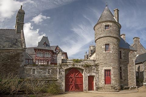
Sights
Events
Twin towns
The town maintains twinning links with: