
Demonym(s) Pontelandolfesi, Ponte Local time Thursday 10:46 PM Postal code 82027 | Elevation 510 m (1,670 ft) Area 28 km² | |
 | ||
Frazioni Acqua del Campo, Carluni, Ciccotto, Giallonardo, Grotte, Guitto, Lena, Malepara, Marziello, Pianelle, Pontelandolfo Scalo, Pontenuovo, Santa Caterina, Santillo, Sorgenza Weather 11°C, Wind NW at 3 km/h, 72% Humidity | ||
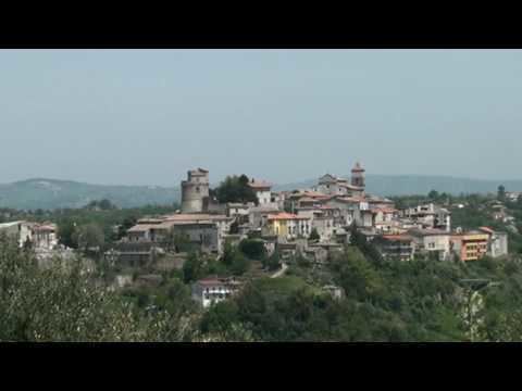
Pontelandolfo is an Italian town and comune of 28.91 square kilometres (11.16 sq mi), in the Sannio Hills in the province of Benevento halfway between Naples and Campobasso, with around 3,000 inhabitants.
Contents
- Map of 82027 Pontelandolfo Province of Benevento Italy
- History
- Geography
- Main sights
- Economy
- Twin towns Sister cities
- References
Map of 82027 Pontelandolfo Province of Benevento, Italy
History
The area of today's Pontelandolfo was settled since very ancient times. The name of the village comes from the legendary Pontis Landulphi, or the Bridge of Landolpho, who died defending the bridge against the Romans while the villagers fled to safety, an event memorialized in the village's crest. The bridge is believed to have spanned the Lenta River.
Pontelandolfo is mostly remembered as the location, along with Casalduni, of a massacre of largely innocent population by the Piedmontese occupation troops in 1861.
Many villagers emigrated to the United States, with a large community settling in and around Waterbury, Connecticut, where they founded the Pontelandolfo Community Club. A large number also moved to Canada, specifically to the city of Montreal.
Geography
Pontelandolfo is located on a mountainous area of Italy. The area that surrounds Pontelandolfo has a wide range of altitudes (400-1,017 meters), with the center of population situated at 525 meters.
There are three prominent mountains that surround Pontelandolfo. These include Mount Calvello, which has an altitude of 1,017 meters, Toppo Mangialardo (917 m) and Mount Forgioso (850 m).
Main sights
Economy
Much of the surrounding area of Pontelandolfo (14.91 km²) is used for agriculture thanks to the fertility of the ground, which was already well known by the ancient Greeks. The primary use of the land is for olive-tree orchards, pastures and for the culture of cereals.
Twin towns — Sister cities
Pontelandolfo is twinned with: